You are here: Home > Network List > IU - Global Seismograph Network (GSN - IRIS/USGS) Stations List
> Station POHA Pohakuloa, Hawaii, USA > Earthquake Result Viewer
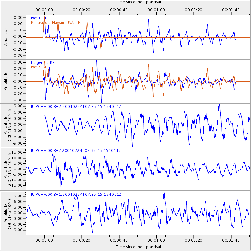
POHA Pohakuloa, Hawaii, USA - Earthquake Result Viewer
*The percent match for this event was below the threshold and hence no stack was calculated.
| Earthquake location: |
Northern Molucca Sea |
| Earthquake latitude/longitude: |
1.3/126.2 |
| Earthquake time(UTC): |
2001/02/24 (055) 07:23:48 GMT |
| Earthquake Depth: |
35 km |
| Earthquake Magnitude: |
6.6 MB, 7.0 MS, 7.1 MW, 7.1 ME |
| Earthquake Catalog/Contributor: |
WHDF/NEIC |
|
| Network: |
IU Global Seismograph Network (GSN - IRIS/USGS) |
| Station: |
POHA Pohakuloa, Hawaii, USA |
| Lat/Lon: |
19.76 N/155.53 W |
| Elevation: |
1967 m |
|
| Distance: |
78.5 deg |
| Az: |
70.213 deg |
| Baz: |
267.201 deg |
| Ray Param: |
$rayparam |
*The percent match for this event was below the threshold and hence was not used in the summary stack. |
|
| Radial Match: |
67.55976 % |
| Radial Bump: |
400 |
| Transverse Match: |
69.24803 % |
| Transverse Bump: |
400 |
| SOD ConfigId: |
590571 |
| Insert Time: |
2013-09-24 20:18:32.799 +0000 |
| GWidth: |
2.5 |
| Max Bumps: |
400 |
| Tol: |
0.001 |
|
Signal To Noise
| Channel | StoN | STA | LTA |
| IU:POHA:00:BHZ:20010224T07:35:15.154011Z | 3.693925 | 4.9097325E-6 | 1.329137E-6 |
| IU:POHA:00:BH1:20010224T07:35:15.154011Z | 0.74844325 | 2.2163458E-6 | 2.9612743E-6 |
| IU:POHA:00:BH2:20010224T07:35:15.154011Z | 1.19705 | 2.8711497E-6 | 2.398521E-6 |
| Arrivals |
| Ps | |
| PpPs | |
| PsPs/PpSs | |


