You are here: Home > Network List > IU - Global Seismograph Network (GSN - IRIS/USGS) Stations List
> Station POHA Pohakuloa, Hawaii, USA > Earthquake Result Viewer
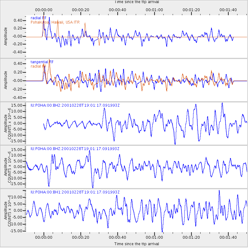
POHA Pohakuloa, Hawaii, USA - Earthquake Result Viewer
*The percent match for this event was below the threshold and hence no stack was calculated.
| Earthquake location: |
Washington |
| Earthquake latitude/longitude: |
47.1/-122.7 |
| Earthquake time(UTC): |
2001/02/28 (059) 18:54:32 GMT |
| Earthquake Depth: |
52 km |
| Earthquake Magnitude: |
6.5 MB, 6.6 MS, 6.8 MW, 6.7 ME |
| Earthquake Catalog/Contributor: |
WHDF/NEIC |
|
| Network: |
IU Global Seismograph Network (GSN - IRIS/USGS) |
| Station: |
POHA Pohakuloa, Hawaii, USA |
| Lat/Lon: |
19.76 N/155.53 W |
| Elevation: |
1967 m |
|
| Distance: |
38.2 deg |
| Az: |
235.615 deg |
| Baz: |
36.731 deg |
| Ray Param: |
$rayparam |
*The percent match for this event was below the threshold and hence was not used in the summary stack. |
|
| Radial Match: |
72.809296 % |
| Radial Bump: |
400 |
| Transverse Match: |
65.84912 % |
| Transverse Bump: |
400 |
| SOD ConfigId: |
590571 |
| Insert Time: |
2013-09-24 20:21:34.890 +0000 |
| GWidth: |
2.5 |
| Max Bumps: |
400 |
| Tol: |
0.001 |
|
Signal To Noise
| Channel | StoN | STA | LTA |
| IU:POHA:00:BHZ:20010228T19:01:17.091993Z | 2.3273938 | 7.377516E-6 | 3.1698617E-6 |
| IU:POHA:00:BH1:20010228T19:01:17.091993Z | 1.5245595 | 4.207714E-6 | 2.7599538E-6 |
| IU:POHA:00:BH2:20010228T19:01:17.091993Z | 3.0942607 | 5.7926304E-6 | 1.8720564E-6 |
| Arrivals |
| Ps | |
| PpPs | |
| PsPs/PpSs | |


