You are here: Home > Network List > II - Global Seismograph Network (GSN - IRIS/IDA) Stations List
> Station MBAR Mbarara, Uganda > Earthquake Result Viewer
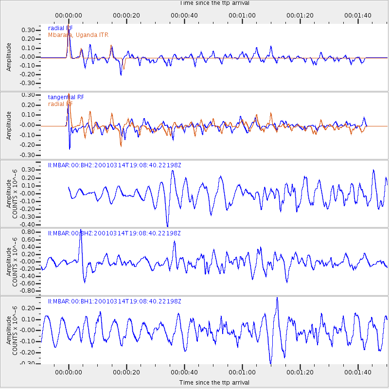
MBAR Mbarara, Uganda - Earthquake Result Viewer
*The percent match for this event was below the threshold and hence no stack was calculated.
| Earthquake location: |
Minahassa Peninsula, Sulawesi |
| Earthquake latitude/longitude: |
0.5/121.9 |
| Earthquake time(UTC): |
2001/03/14 (073) 18:56:18 GMT |
| Earthquake Depth: |
109 km |
| Earthquake Magnitude: |
5.9 MB, 6.0 MW, 5.9 MW |
| Earthquake Catalog/Contributor: |
WHDF/NEIC |
|
| Network: |
II Global Seismograph Network (GSN - IRIS/IDA) |
| Station: |
MBAR Mbarara, Uganda |
| Lat/Lon: |
0.60 S/30.74 E |
| Elevation: |
1390 m |
|
| Distance: |
91.2 deg |
| Az: |
269.411 deg |
| Baz: |
89.564 deg |
| Ray Param: |
$rayparam |
*The percent match for this event was below the threshold and hence was not used in the summary stack. |
|
| Radial Match: |
50.263065 % |
| Radial Bump: |
341 |
| Transverse Match: |
54.70201 % |
| Transverse Bump: |
400 |
| SOD ConfigId: |
590571 |
| Insert Time: |
2013-09-24 20:25:00.983 +0000 |
| GWidth: |
2.5 |
| Max Bumps: |
400 |
| Tol: |
0.001 |
|
Signal To Noise
| Channel | StoN | STA | LTA |
| II:MBAR:00:BHZ:20010314T19:08:40.22198Z | 3.2353005 | 2.975295E-7 | 9.196348E-8 |
| II:MBAR:00:BH1:20010314T19:08:40.22198Z | 0.6592735 | 5.169714E-8 | 7.841531E-8 |
| II:MBAR:00:BH2:20010314T19:08:40.22198Z | 3.7102811 | 1.859088E-7 | 5.0106394E-8 |
| Arrivals |
| Ps | |
| PpPs | |
| PsPs/PpSs | |


