You are here: Home > Network List > II - Global Seismograph Network (GSN - IRIS/IDA) Stations List
> Station MBAR Mbarara, Uganda > Earthquake Result Viewer
MBAR Mbarara, Uganda - Earthquake Result Viewer
| Earthquake location: |
Seram, Indonesia |
| Earthquake latitude/longitude: |
-4.0/127.8 |
| Earthquake time(UTC): |
2001/03/19 (078) 05:56:57 GMT |
| Earthquake Depth: |
33 km |
| Earthquake Magnitude: |
5.8 MB |
| Earthquake Catalog/Contributor: |
WHDF/NEIC |
|
| Network: |
II Global Seismograph Network (GSN - IRIS/IDA) |
| Station: |
MBAR Mbarara, Uganda |
| Lat/Lon: |
0.60 S/30.74 E |
| Elevation: |
1390 m |
|
| Distance: |
97.0 deg |
| Az: |
268.904 deg |
| Baz: |
94.077 deg |
| Ray Param: |
0.040315196 |
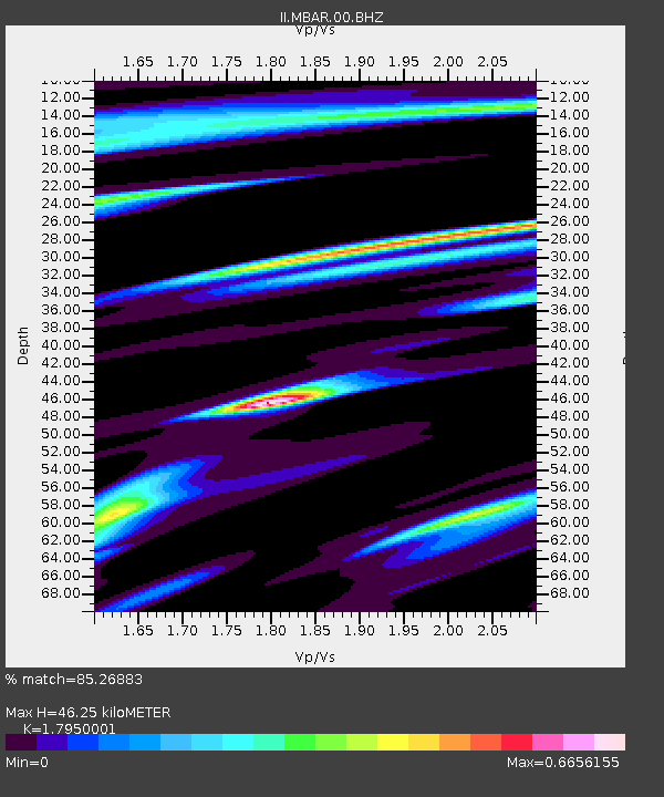
| Estimated Moho Depth: |
46.25 km |
| Estimated Crust Vp/Vs: |
1.80 |
| Assumed Crust Vp: |
6.419 km/s |
| Estimated Crust Vs: |
3.576 km/s |
| Estimated Crust Poisson's Ratio: |
0.27 |
|
| Radial Match: |
85.26883 % |
| Radial Bump: |
323 |
| Transverse Match: |
73.4103 % |
| Transverse Bump: |
400 |
| SOD ConfigId: |
590571 |
| Insert Time: |
2013-09-24 20:26:56.067 +0000 |
| GWidth: |
2.5 |
| Max Bumps: |
400 |
| Tol: |
0.001 |
|

Signal To Noise
| Channel | StoN | STA | LTA |
| II:MBAR:00:BHZ:20010319T06:09:54.111003Z | 0.7060492 | 2.1406728E-7 | 3.0319032E-7 |
| II:MBAR:00:BH1:20010319T06:09:54.111003Z | 1.509256 | 1.2263754E-7 | 8.125696E-8 |
| II:MBAR:00:BH2:20010319T06:09:54.111003Z | 1.0587755 | 1.4196429E-7 | 1.3408346E-7 |
| Arrivals |
| Ps | 5.8 SECOND |
| PpPs | 20 SECOND |
| PsPs/PpSs | 26 SECOND |


