You are here: Home > Network List > TA - USArray Transportable Network (new EarthScope stations) Stations List
> Station A36M Sachs Harbour, NT, CAN > Earthquake Result Viewer
A36M Sachs Harbour, NT, CAN - Earthquake Result Viewer
| Earthquake location: |
Mindanao, Philippines |
| Earthquake latitude/longitude: |
6.8/125.1 |
| Earthquake time(UTC): |
2014/09/19 (262) 23:09:55 GMT |
| Earthquake Depth: |
21 km |
| Earthquake Magnitude: |
4.8 MW |
| Earthquake Catalog/Contributor: |
ISC/ISC |
|
| Network: |
TA USArray Transportable Network (new EarthScope stations) |
| Station: |
A36M Sachs Harbour, NT, CAN |
| Lat/Lon: |
71.99 N/125.25 W |
| Elevation: |
32 m |
|
| Distance: |
89.6 deg |
| Az: |
17.039 deg |
| Baz: |
290.717 deg |
| Ray Param: |
0.041741647 |
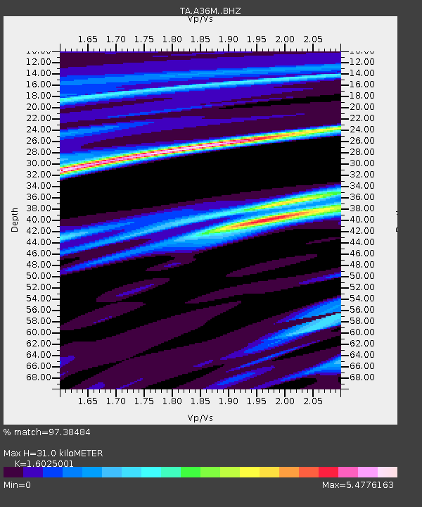
| Estimated Moho Depth: |
31.0 km |
| Estimated Crust Vp/Vs: |
1.60 |
| Assumed Crust Vp: |
6.24 km/s |
| Estimated Crust Vs: |
3.894 km/s |
| Estimated Crust Poisson's Ratio: |
0.18 |
|
| Radial Match: |
97.38484 % |
| Radial Bump: |
306 |
| Transverse Match: |
85.75525 % |
| Transverse Bump: |
400 |
| SOD ConfigId: |
3390531 |
| Insert Time: |
2019-04-14 03:06:39.181 +0000 |
| GWidth: |
2.5 |
| Max Bumps: |
400 |
| Tol: |
0.001 |
|
Signal To Noise
| Channel | StoN | STA | LTA |
| TA:A36M: :BHZ:20140919T23:22:19.674028Z | 2.6747653 | 5.308702E-6 | 1.9847355E-6 |
| TA:A36M: :BHN:20140919T23:22:19.674028Z | 3.5023358 | 1.3016865E-5 | 3.7166237E-6 |
| TA:A36M: :BHE:20140919T23:22:19.674028Z | 4.202909 | 5.2355652E-5 | 1.2457003E-5 |
| Arrivals |
| Ps | 3.1 SECOND |
| PpPs | 13 SECOND |
| PsPs/PpSs | 16 SECOND |


