You are here: Home > Network List > IU - Global Seismograph Network (GSN - IRIS/USGS) Stations List
> Station TEIG Tepich, Yucatan, Mexico > Earthquake Result Viewer
TEIG Tepich, Yucatan, Mexico - Earthquake Result Viewer
| Earthquake location: |
Off Coast Of Central Chile |
| Earthquake latitude/longitude: |
-32.7/-73.1 |
| Earthquake time(UTC): |
2001/04/09 (099) 09:00:57 GMT |
| Earthquake Depth: |
11 km |
| Earthquake Magnitude: |
6.1 MB, 6.3 MS, 6.7 MW, 6.3 ME |
| Earthquake Catalog/Contributor: |
WHDF/NEIC |
|
| Network: |
IU Global Seismograph Network (GSN - IRIS/USGS) |
| Station: |
TEIG Tepich, Yucatan, Mexico |
| Lat/Lon: |
20.23 N/88.28 W |
| Elevation: |
69 m |
|
| Distance: |
54.6 deg |
| Az: |
342.447 deg |
| Baz: |
164.284 deg |
| Ray Param: |
0.065369464 |
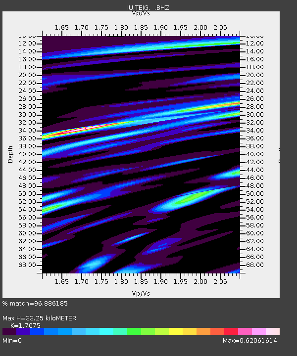
| Estimated Moho Depth: |
33.25 km |
| Estimated Crust Vp/Vs: |
1.71 |
| Assumed Crust Vp: |
5.817 km/s |
| Estimated Crust Vs: |
3.407 km/s |
| Estimated Crust Poisson's Ratio: |
0.24 |
|
| Radial Match: |
96.886185 % |
| Radial Bump: |
400 |
| Transverse Match: |
63.120453 % |
| Transverse Bump: |
400 |
| SOD ConfigId: |
590571 |
| Insert Time: |
2013-09-24 20:32:15.847 +0000 |
| GWidth: |
2.5 |
| Max Bumps: |
400 |
| Tol: |
0.001 |
|

Signal To Noise
| Channel | StoN | STA | LTA |
| IU:TEIG: :BHZ:20010409T09:09:54.234026Z | 2.3990433 | 4.7936953E-7 | 1.9981695E-7 |
| IU:TEIG: :BH1:20010409T09:09:54.234026Z | 0.66333145 | 3.206415E-7 | 4.833806E-7 |
| IU:TEIG: :BH2:20010409T09:09:54.234026Z | 1.4832009 | 5.539966E-7 | 3.735142E-7 |
| Arrivals |
| Ps | 4.2 SECOND |
| PpPs | 15 SECOND |
| PsPs/PpSs | 19 SECOND |


