You are here: Home > Network List > IU - Global Seismograph Network (GSN - IRIS/USGS) Stations List
> Station RSSD Black Hills, South Dakota, USA > Earthquake Result Viewer
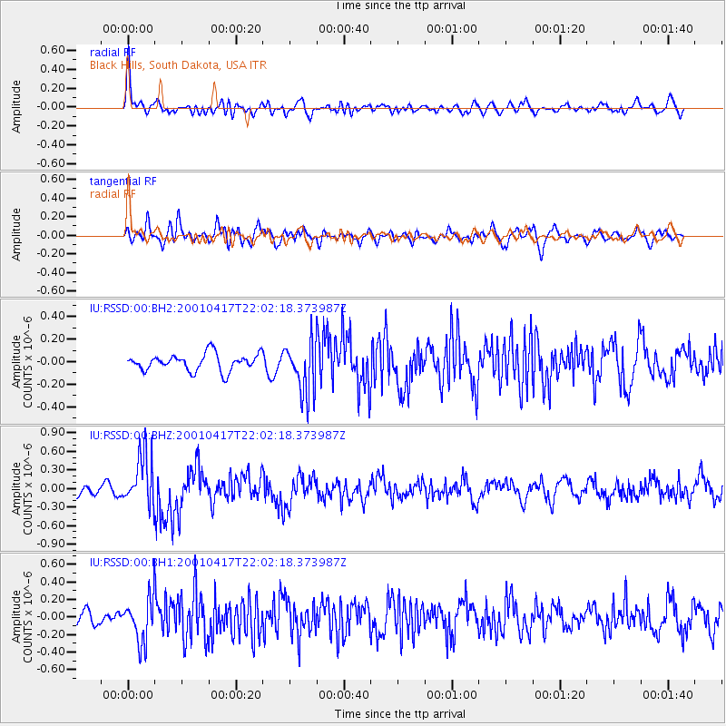
RSSD Black Hills, South Dakota, USA - Earthquake Result Viewer
*The percent match for this event was below the threshold and hence no stack was calculated.
| Earthquake location: |
Andreanof Islands, Aleutian Is. |
| Earthquake latitude/longitude: |
51.2/-179.8 |
| Earthquake time(UTC): |
2001/04/17 (107) 21:54:02 GMT |
| Earthquake Depth: |
33 km |
| Earthquake Magnitude: |
5.8 MB, 5.5 MS, 6.0 MW, 5.9 ML |
| Earthquake Catalog/Contributor: |
WHDF/NEIC |
|
| Network: |
IU Global Seismograph Network (GSN - IRIS/USGS) |
| Station: |
RSSD Black Hills, South Dakota, USA |
| Lat/Lon: |
44.12 N/104.04 W |
| Elevation: |
2060 m |
|
| Distance: |
49.4 deg |
| Az: |
66.869 deg |
| Baz: |
306.614 deg |
| Ray Param: |
$rayparam |
*The percent match for this event was below the threshold and hence was not used in the summary stack. |
|
| Radial Match: |
71.839775 % |
| Radial Bump: |
400 |
| Transverse Match: |
62.27328 % |
| Transverse Bump: |
400 |
| SOD ConfigId: |
590571 |
| Insert Time: |
2013-09-24 20:34:25.011 +0000 |
| GWidth: |
2.5 |
| Max Bumps: |
400 |
| Tol: |
0.001 |
|
Signal To Noise
| Channel | StoN | STA | LTA |
| IU:RSSD:00:BHZ:20010417T22:02:18.373987Z | 4.55952 | 4.2499667E-7 | 9.321084E-8 |
| IU:RSSD:00:BH1:20010417T22:02:18.373987Z | 2.5080714 | 2.5918206E-7 | 1.0333919E-7 |
| IU:RSSD:00:BH2:20010417T22:02:18.373987Z | 3.1278398 | 2.347264E-7 | 7.504425E-8 |
| Arrivals |
| Ps | |
| PpPs | |
| PsPs/PpSs | |


