You are here: Home > Network List > II - Global Seismograph Network (GSN - IRIS/IDA) Stations List
> Station MBAR Mbarara, Uganda > Earthquake Result Viewer
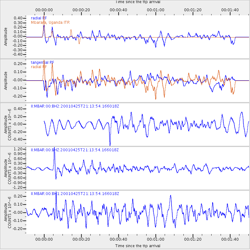
MBAR Mbarara, Uganda - Earthquake Result Viewer
*The percent match for this event was below the threshold and hence no stack was calculated.
| Earthquake location: |
South Of Java, Indonesia |
| Earthquake latitude/longitude: |
-9.2/106.5 |
| Earthquake time(UTC): |
2001/04/25 (115) 21:02:42 GMT |
| Earthquake Depth: |
33 km |
| Earthquake Magnitude: |
5.5 MW, 5.5 MW, 5.5 MB |
| Earthquake Catalog/Contributor: |
NEIC PDE/NEIC PDE-M |
|
| Network: |
II Global Seismograph Network (GSN - IRIS/IDA) |
| Station: |
MBAR Mbarara, Uganda |
| Lat/Lon: |
0.60 S/30.74 E |
| Elevation: |
1390 m |
|
| Distance: |
75.8 deg |
| Az: |
271.698 deg |
| Baz: |
99.259 deg |
| Ray Param: |
$rayparam |
*The percent match for this event was below the threshold and hence was not used in the summary stack. |
|
| Radial Match: |
58.39656 % |
| Radial Bump: |
400 |
| Transverse Match: |
52.22016 % |
| Transverse Bump: |
400 |
| SOD ConfigId: |
590571 |
| Insert Time: |
2013-09-24 20:38:27.691 +0000 |
| GWidth: |
2.5 |
| Max Bumps: |
400 |
| Tol: |
0.001 |
|
Signal To Noise
| Channel | StoN | STA | LTA |
| II:MBAR:00:BHZ:20010425T21:13:54.166018Z | 0.7617667 | 6.2162E-8 | 8.1602415E-8 |
| II:MBAR:00:BH1:20010425T21:13:54.166018Z | 0.76874346 | 5.9848226E-8 | 7.7852015E-8 |
| II:MBAR:00:BH2:20010425T21:13:54.166018Z | 0.8234203 | 8.508887E-8 | 1.0333589E-7 |
| Arrivals |
| Ps | |
| PpPs | |
| PsPs/PpSs | |


