You are here: Home > Network List > IU - Global Seismograph Network (GSN - IRIS/USGS) Stations List
> Station RSSD Black Hills, South Dakota, USA > Earthquake Result Viewer
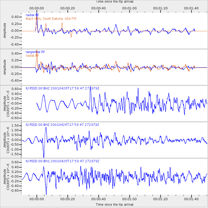
RSSD Black Hills, South Dakota, USA - Earthquake Result Viewer
*The percent match for this event was below the threshold and hence no stack was calculated.
| Earthquake location: |
Hokkaido, Japan Region |
| Earthquake latitude/longitude: |
43.1/145.9 |
| Earthquake time(UTC): |
2001/04/26 (116) 17:48:57 GMT |
| Earthquake Depth: |
86 km |
| Earthquake Magnitude: |
5.7 MB, 6.0 MW, 6.0 MW |
| Earthquake Catalog/Contributor: |
WHDF/NEIC |
|
| Network: |
IU Global Seismograph Network (GSN - IRIS/USGS) |
| Station: |
RSSD Black Hills, South Dakota, USA |
| Lat/Lon: |
44.12 N/104.04 W |
| Elevation: |
2060 m |
|
| Distance: |
73.1 deg |
| Az: |
45.018 deg |
| Baz: |
313.997 deg |
| Ray Param: |
$rayparam |
*The percent match for this event was below the threshold and hence was not used in the summary stack. |
|
| Radial Match: |
70.081406 % |
| Radial Bump: |
345 |
| Transverse Match: |
61.376217 % |
| Transverse Bump: |
400 |
| SOD ConfigId: |
590571 |
| Insert Time: |
2013-09-24 20:38:47.524 +0000 |
| GWidth: |
2.5 |
| Max Bumps: |
400 |
| Tol: |
0.001 |
|
Signal To Noise
| Channel | StoN | STA | LTA |
| IU:RSSD:00:BHZ:20010426T17:59:47.272979Z | 7.214225 | 5.965523E-7 | 8.2691116E-8 |
| IU:RSSD:00:BH1:20010426T17:59:47.272979Z | 1.7849476 | 1.5687081E-7 | 8.788538E-8 |
| IU:RSSD:00:BH2:20010426T17:59:47.272979Z | 1.3721253 | 2.2078376E-7 | 1.6090642E-7 |
| Arrivals |
| Ps | |
| PpPs | |
| PsPs/PpSs | |


