You are here: Home > Network List > IU - Global Seismograph Network (GSN - IRIS/USGS) Stations List
> Station JOHN Johnston Island, USA > Earthquake Result Viewer
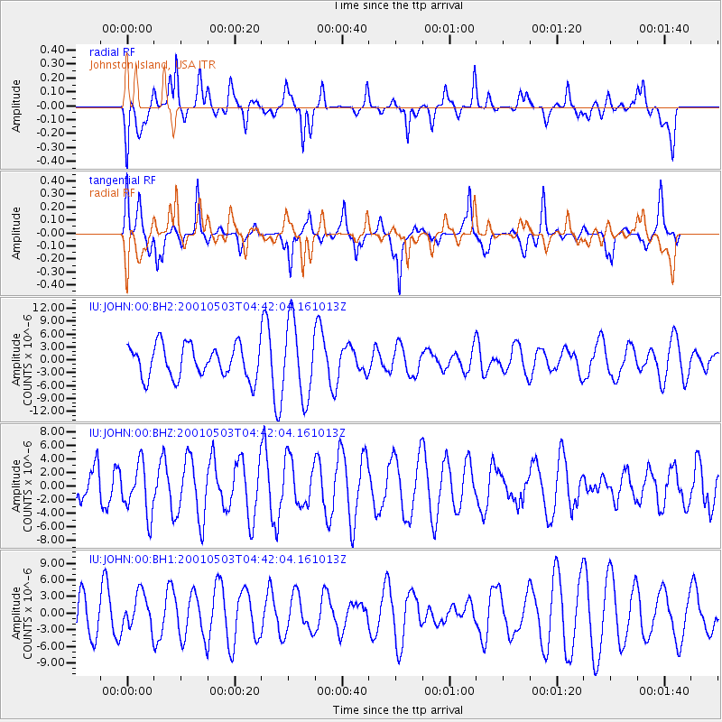
JOHN Johnston Island, USA - Earthquake Result Viewer
*The percent match for this event was below the threshold and hence no stack was calculated.
| Earthquake location: |
Northern Molucca Sea |
| Earthquake latitude/longitude: |
0.5/126.3 |
| Earthquake time(UTC): |
2001/05/03 (123) 04:31:57 GMT |
| Earthquake Depth: |
33 km |
| Earthquake Magnitude: |
5.7 MB, 5.4 MS, 5.8 MW, 5.5 MW |
| Earthquake Catalog/Contributor: |
WHDF/NEIC |
|
| Network: |
IU Global Seismograph Network (GSN - IRIS/USGS) |
| Station: |
JOHN Johnston Island, USA |
| Lat/Lon: |
16.73 N/169.53 W |
| Elevation: |
2.0 m |
|
| Distance: |
65.2 deg |
| Az: |
71.847 deg |
| Baz: |
262.595 deg |
| Ray Param: |
$rayparam |
*The percent match for this event was below the threshold and hence was not used in the summary stack. |
|
| Radial Match: |
60.66475 % |
| Radial Bump: |
400 |
| Transverse Match: |
56.5449 % |
| Transverse Bump: |
305 |
| SOD ConfigId: |
590571 |
| Insert Time: |
2013-09-24 20:40:12.281 +0000 |
| GWidth: |
2.5 |
| Max Bumps: |
400 |
| Tol: |
0.001 |
|
Signal To Noise
| Channel | StoN | STA | LTA |
| IU:JOHN:00:BHZ:20010503T04:42:04.161013Z | 1.0013441 | 3.76823E-6 | 3.7631721E-6 |
| IU:JOHN:00:BH1:20010503T04:42:04.161013Z | 1.1245856 | 3.1897764E-6 | 2.8364016E-6 |
| IU:JOHN:00:BH2:20010503T04:42:04.161013Z | 2.3406014 | 8.808701E-6 | 3.7634347E-6 |
| Arrivals |
| Ps | |
| PpPs | |
| PsPs/PpSs | |


