You are here: Home > Network List > IU - Global Seismograph Network (GSN - IRIS/USGS) Stations List
> Station RSSD Black Hills, South Dakota, USA > Earthquake Result Viewer
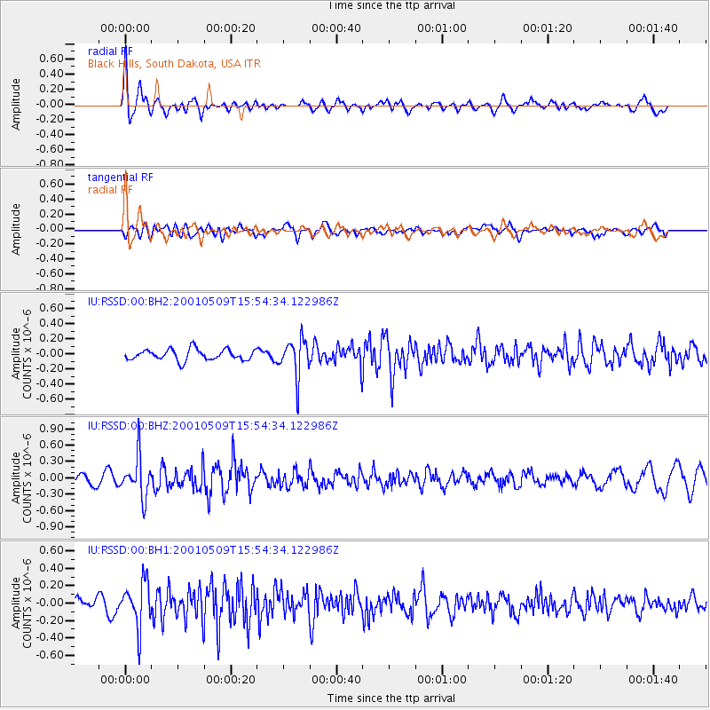
RSSD Black Hills, South Dakota, USA - Earthquake Result Viewer
*The percent match for this event was below the threshold and hence no stack was calculated.
| Earthquake location: |
Unimak Island Region, Alaska |
| Earthquake latitude/longitude: |
53.6/-164.3 |
| Earthquake time(UTC): |
2001/05/09 (129) 15:47:36 GMT |
| Earthquake Depth: |
42 km |
| Earthquake Magnitude: |
5.8 MB, 5.0 MS, 5.7 MW, 5.2 ML |
| Earthquake Catalog/Contributor: |
WHDF/NEIC |
|
| Network: |
IU Global Seismograph Network (GSN - IRIS/USGS) |
| Station: |
RSSD Black Hills, South Dakota, USA |
| Lat/Lon: |
44.12 N/104.04 W |
| Elevation: |
2060 m |
|
| Distance: |
39.7 deg |
| Az: |
78.589 deg |
| Baz: |
305.865 deg |
| Ray Param: |
$rayparam |
*The percent match for this event was below the threshold and hence was not used in the summary stack. |
|
| Radial Match: |
68.529564 % |
| Radial Bump: |
400 |
| Transverse Match: |
53.864986 % |
| Transverse Bump: |
400 |
| SOD ConfigId: |
590571 |
| Insert Time: |
2013-09-24 20:42:04.958 +0000 |
| GWidth: |
2.5 |
| Max Bumps: |
400 |
| Tol: |
0.001 |
|
Signal To Noise
| Channel | StoN | STA | LTA |
| IU:RSSD:00:BHZ:20010509T15:54:34.122986Z | 5.75667 | 3.7555043E-7 | 6.5237444E-8 |
| IU:RSSD:00:BH1:20010509T15:54:34.122986Z | 3.9227574 | 2.5994225E-7 | 6.626519E-8 |
| IU:RSSD:00:BH2:20010509T15:54:34.122986Z | 3.5605807 | 2.5229483E-7 | 7.085777E-8 |
| Arrivals |
| Ps | |
| PpPs | |
| PsPs/PpSs | |


