You are here: Home > Network List > IU - Global Seismograph Network (GSN - IRIS/USGS) Stations List
> Station RSSD Black Hills, South Dakota, USA > Earthquake Result Viewer
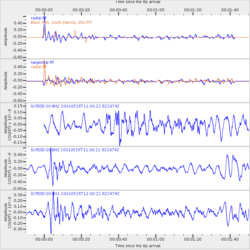
RSSD Black Hills, South Dakota, USA - Earthquake Result Viewer
*The percent match for this event was below the threshold and hence no stack was calculated.
| Earthquake location: |
Fiji Islands Region |
| Earthquake latitude/longitude: |
-20.3/-177.8 |
| Earthquake time(UTC): |
2001/05/26 (146) 10:57:26 GMT |
| Earthquake Depth: |
406 km |
| Earthquake Magnitude: |
5.3 MB, 6.4 MW, 6.4 MW |
| Earthquake Catalog/Contributor: |
WHDF/NEIC |
|
| Network: |
IU Global Seismograph Network (GSN - IRIS/USGS) |
| Station: |
RSSD Black Hills, South Dakota, USA |
| Lat/Lon: |
44.12 N/104.04 W |
| Elevation: |
2060 m |
|
| Distance: |
92.9 deg |
| Az: |
43.83 deg |
| Baz: |
244.502 deg |
| Ray Param: |
$rayparam |
*The percent match for this event was below the threshold and hence was not used in the summary stack. |
|
| Radial Match: |
67.612434 % |
| Radial Bump: |
400 |
| Transverse Match: |
46.15487 % |
| Transverse Bump: |
324 |
| SOD ConfigId: |
590571 |
| Insert Time: |
2013-09-24 20:45:58.015 +0000 |
| GWidth: |
2.5 |
| Max Bumps: |
400 |
| Tol: |
0.001 |
|
Signal To Noise
| Channel | StoN | STA | LTA |
| IU:RSSD:00:BHZ:20010526T11:09:22.822974Z | 3.6079297 | 2.4090974E-7 | 6.6772294E-8 |
| IU:RSSD:00:BH1:20010526T11:09:22.822974Z | 5.318546 | 1.4707682E-7 | 2.7653579E-8 |
| IU:RSSD:00:BH2:20010526T11:09:22.822974Z | 1.0776578 | 4.803242E-8 | 4.457112E-8 |
| Arrivals |
| Ps | |
| PpPs | |
| PsPs/PpSs | |


