You are here: Home > Network List > II - Global Seismograph Network (GSN - IRIS/IDA) Stations List
> Station PALK Pallekele, Sri Lanka > Earthquake Result Viewer
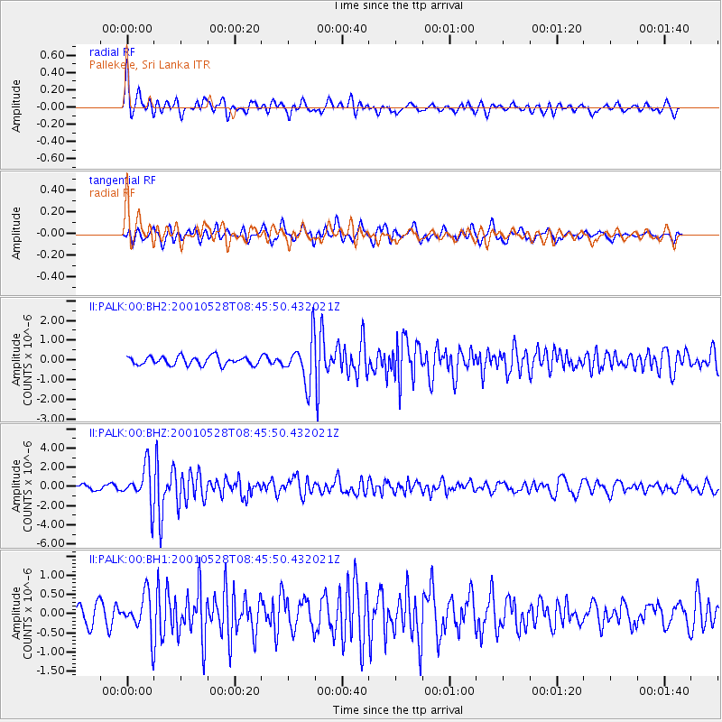
PALK Pallekele, Sri Lanka - Earthquake Result Viewer
*The percent match for this event was below the threshold and hence no stack was calculated.
| Earthquake location: |
Tanimbar Islands Reg., Indonesia |
| Earthquake latitude/longitude: |
-6.6/132.3 |
| Earthquake time(UTC): |
2001/05/28 (148) 08:37:05 GMT |
| Earthquake Depth: |
33 km |
| Earthquake Magnitude: |
5.9 MB, 5.3 MS, 6.1 MW, 6.0 MW |
| Earthquake Catalog/Contributor: |
WHDF/NEIC |
|
| Network: |
II Global Seismograph Network (GSN - IRIS/IDA) |
| Station: |
PALK Pallekele, Sri Lanka |
| Lat/Lon: |
7.27 N/80.70 E |
| Elevation: |
460 m |
|
| Distance: |
53.3 deg |
| Az: |
284.094 deg |
| Baz: |
103.773 deg |
| Ray Param: |
$rayparam |
*The percent match for this event was below the threshold and hence was not used in the summary stack. |
|
| Radial Match: |
75.2073 % |
| Radial Bump: |
400 |
| Transverse Match: |
72.10994 % |
| Transverse Bump: |
400 |
| SOD ConfigId: |
590571 |
| Insert Time: |
2013-09-24 20:46:22.545 +0000 |
| GWidth: |
2.5 |
| Max Bumps: |
400 |
| Tol: |
0.001 |
|
Signal To Noise
| Channel | StoN | STA | LTA |
| II:PALK:00:BHZ:20010528T08:45:50.432021Z | 5.468364 | 2.0286086E-6 | 3.7097178E-7 |
| II:PALK:00:BH1:20010528T08:45:50.432021Z | 1.8129746 | 5.302861E-7 | 2.9249506E-7 |
| II:PALK:00:BH2:20010528T08:45:50.432021Z | 5.226377 | 1.112972E-6 | 2.1295288E-7 |
| Arrivals |
| Ps | |
| PpPs | |
| PsPs/PpSs | |


