You are here: Home > Network List > IU - Global Seismograph Network (GSN - IRIS/USGS) Stations List
> Station RSSD Black Hills, South Dakota, USA > Earthquake Result Viewer
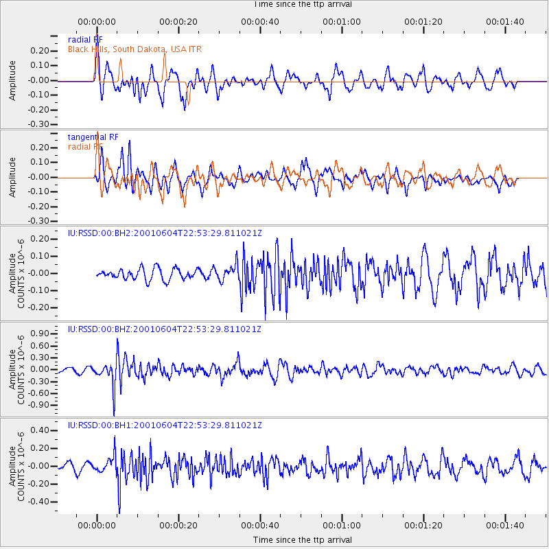
RSSD Black Hills, South Dakota, USA - Earthquake Result Viewer
*The percent match for this event was below the threshold and hence no stack was calculated.
| Earthquake location: |
Mariana Islands |
| Earthquake latitude/longitude: |
17.1/145.8 |
| Earthquake time(UTC): |
2001/06/04 (155) 22:41:01 GMT |
| Earthquake Depth: |
83 km |
| Earthquake Magnitude: |
5.7 MB, 5.8 MW, 5.7 MW |
| Earthquake Catalog/Contributor: |
WHDF/NEIC |
|
| Network: |
IU Global Seismograph Network (GSN - IRIS/USGS) |
| Station: |
RSSD Black Hills, South Dakota, USA |
| Lat/Lon: |
44.12 N/104.04 W |
| Elevation: |
2060 m |
|
| Distance: |
92.0 deg |
| Az: |
42.579 deg |
| Baz: |
296.044 deg |
| Ray Param: |
$rayparam |
*The percent match for this event was below the threshold and hence was not used in the summary stack. |
|
| Radial Match: |
68.229454 % |
| Radial Bump: |
400 |
| Transverse Match: |
72.28392 % |
| Transverse Bump: |
376 |
| SOD ConfigId: |
590571 |
| Insert Time: |
2013-09-24 20:48:36.035 +0000 |
| GWidth: |
2.5 |
| Max Bumps: |
400 |
| Tol: |
0.001 |
|
Signal To Noise
| Channel | StoN | STA | LTA |
| IU:RSSD:00:BHZ:20010604T22:53:29.811021Z | 5.4435143 | 2.979406E-7 | 5.473314E-8 |
| IU:RSSD:00:BH1:20010604T22:53:29.811021Z | 2.0891502 | 9.499095E-8 | 4.5468703E-8 |
| IU:RSSD:00:BH2:20010604T22:53:29.811021Z | 1.4449209 | 4.5851706E-8 | 3.1733023E-8 |
| Arrivals |
| Ps | |
| PpPs | |
| PsPs/PpSs | |


