You are here: Home > Network List > IU - Global Seismograph Network (GSN - IRIS/USGS) Stations List
> Station RSSD Black Hills, South Dakota, USA > Earthquake Result Viewer
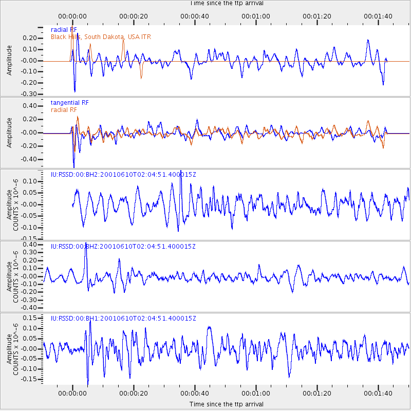
RSSD Black Hills, South Dakota, USA - Earthquake Result Viewer
*The percent match for this event was below the threshold and hence no stack was calculated.
| Earthquake location: |
Turkmenistan |
| Earthquake latitude/longitude: |
39.9/53.9 |
| Earthquake time(UTC): |
2001/06/10 (161) 01:52:08 GMT |
| Earthquake Depth: |
34 km |
| Earthquake Magnitude: |
5.5 MB, 5.2 MS, 5.4 MW, 5.4 MW |
| Earthquake Catalog/Contributor: |
WHDF/NEIC |
|
| Network: |
IU Global Seismograph Network (GSN - IRIS/USGS) |
| Station: |
RSSD Black Hills, South Dakota, USA |
| Lat/Lon: |
44.12 N/104.04 W |
| Elevation: |
2060 m |
|
| Distance: |
94.1 deg |
| Az: |
344.256 deg |
| Baz: |
16.854 deg |
| Ray Param: |
$rayparam |
*The percent match for this event was below the threshold and hence was not used in the summary stack. |
|
| Radial Match: |
57.227013 % |
| Radial Bump: |
400 |
| Transverse Match: |
63.329556 % |
| Transverse Bump: |
400 |
| SOD ConfigId: |
590571 |
| Insert Time: |
2013-09-24 20:49:51.364 +0000 |
| GWidth: |
2.5 |
| Max Bumps: |
400 |
| Tol: |
0.001 |
|
Signal To Noise
| Channel | StoN | STA | LTA |
| IU:RSSD:00:BHZ:20010610T02:04:51.400015Z | 2.5294077 | 1.4477203E-7 | 5.7235546E-8 |
| IU:RSSD:00:BH1:20010610T02:04:51.400015Z | 1.0547655 | 3.564007E-8 | 3.378957E-8 |
| IU:RSSD:00:BH2:20010610T02:04:51.400015Z | 1.4875218 | 5.9887206E-8 | 4.0259714E-8 |
| Arrivals |
| Ps | |
| PpPs | |
| PsPs/PpSs | |


