You are here: Home > Network List > II - Global Seismograph Network (GSN - IRIS/IDA) Stations List
> Station MBAR Mbarara, Uganda > Earthquake Result Viewer
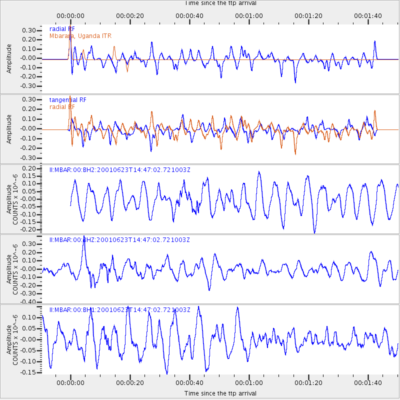
MBAR Mbarara, Uganda - Earthquake Result Viewer
*The percent match for this event was below the threshold and hence no stack was calculated.
| Earthquake location: |
Northern Molucca Sea |
| Earthquake latitude/longitude: |
1.4/125.7 |
| Earthquake time(UTC): |
2001/06/23 (174) 14:34:19 GMT |
| Earthquake Depth: |
70 km |
| Earthquake Magnitude: |
5.6 MB, 5.7 MW, 5.7 MW |
| Earthquake Catalog/Contributor: |
WHDF/NEIC |
|
| Network: |
II Global Seismograph Network (GSN - IRIS/IDA) |
| Station: |
MBAR Mbarara, Uganda |
| Lat/Lon: |
0.60 S/30.74 E |
| Elevation: |
1390 m |
|
| Distance: |
95.0 deg |
| Az: |
269.524 deg |
| Baz: |
88.613 deg |
| Ray Param: |
$rayparam |
*The percent match for this event was below the threshold and hence was not used in the summary stack. |
|
| Radial Match: |
30.731413 % |
| Radial Bump: |
321 |
| Transverse Match: |
55.415974 % |
| Transverse Bump: |
371 |
| SOD ConfigId: |
590571 |
| Insert Time: |
2013-09-24 20:54:44.056 +0000 |
| GWidth: |
2.5 |
| Max Bumps: |
400 |
| Tol: |
0.001 |
|
Signal To Noise
| Channel | StoN | STA | LTA |
| II:MBAR:00:BHZ:20010623T14:47:02.721003Z | 2.6991315 | 1.5076861E-7 | 5.5858195E-8 |
| II:MBAR:00:BH1:20010623T14:47:02.721003Z | 0.8553937 | 4.0485098E-8 | 4.73292E-8 |
| II:MBAR:00:BH2:20010623T14:47:02.721003Z | 0.8075164 | 5.742392E-8 | 7.111178E-8 |
| Arrivals |
| Ps | |
| PpPs | |
| PsPs/PpSs | |


