You are here: Home > Network List > IU - Global Seismograph Network (GSN - IRIS/USGS) Stations List
> Station RSSD Black Hills, South Dakota, USA > Earthquake Result Viewer
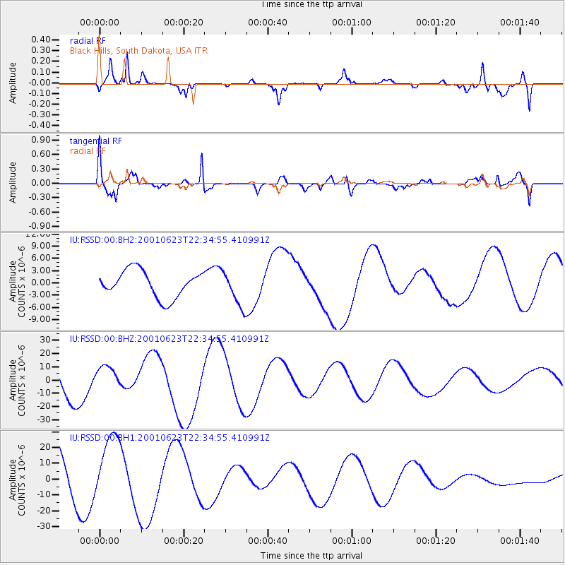
RSSD Black Hills, South Dakota, USA - Earthquake Result Viewer
*The percent match for this event was below the threshold and hence no stack was calculated.
| Earthquake location: |
Near Coast Of Peru |
| Earthquake latitude/longitude: |
-16.6/-73.6 |
| Earthquake time(UTC): |
2001/06/23 (174) 22:24:39 GMT |
| Earthquake Depth: |
33 km |
| Earthquake Magnitude: |
5.7 MB |
| Earthquake Catalog/Contributor: |
NEIC PDE/NEIC PDE-M |
|
| Network: |
IU Global Seismograph Network (GSN - IRIS/USGS) |
| Station: |
RSSD Black Hills, South Dakota, USA |
| Lat/Lon: |
44.12 N/104.04 W |
| Elevation: |
2060 m |
|
| Distance: |
66.6 deg |
| Az: |
336.572 deg |
| Baz: |
148.048 deg |
| Ray Param: |
$rayparam |
*The percent match for this event was below the threshold and hence was not used in the summary stack. |
|
| Radial Match: |
67.508446 % |
| Radial Bump: |
400 |
| Transverse Match: |
74.411316 % |
| Transverse Bump: |
400 |
| SOD ConfigId: |
590571 |
| Insert Time: |
2013-09-24 20:56:06.071 +0000 |
| GWidth: |
2.5 |
| Max Bumps: |
400 |
| Tol: |
0.001 |
|
Signal To Noise
| Channel | StoN | STA | LTA |
| IU:RSSD:00:BHZ:20010623T22:34:55.410991Z | 0.7092097 | 9.420335E-6 | 1.3282864E-5 |
| IU:RSSD:00:BH1:20010623T22:34:55.410991Z | 1.5214617 | 2.09686E-5 | 1.3781878E-5 |
| IU:RSSD:00:BH2:20010623T22:34:55.410991Z | 1.3592225 | 4.456957E-6 | 3.279049E-6 |
| Arrivals |
| Ps | |
| PpPs | |
| PsPs/PpSs | |


