You are here: Home > Network List > IU - Global Seismograph Network (GSN - IRIS/USGS) Stations List
> Station RSSD Black Hills, South Dakota, USA > Earthquake Result Viewer
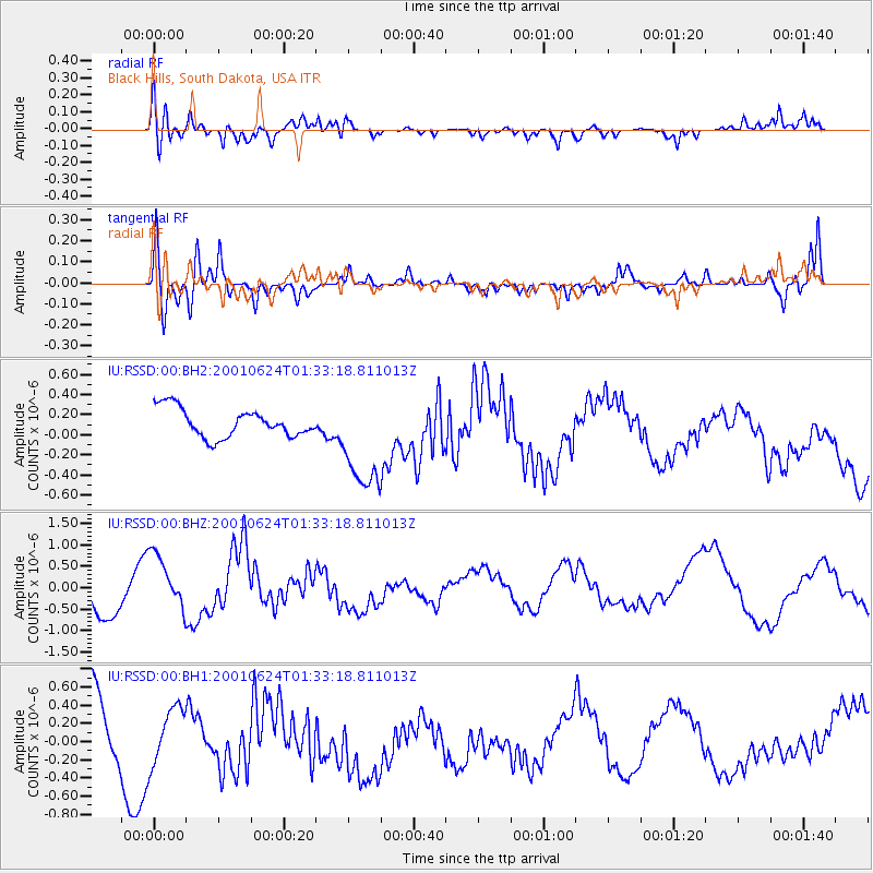
RSSD Black Hills, South Dakota, USA - Earthquake Result Viewer
*The percent match for this event was below the threshold and hence no stack was calculated.
| Earthquake location: |
Near Coast Of Peru |
| Earthquake latitude/longitude: |
-17.6/-72.0 |
| Earthquake time(UTC): |
2001/06/24 (175) 01:22:53 GMT |
| Earthquake Depth: |
33 km |
| Earthquake Magnitude: |
5.5 MS |
| Earthquake Catalog/Contributor: |
NEIC PDE/NEIC PDE-M |
|
| Network: |
IU Global Seismograph Network (GSN - IRIS/USGS) |
| Station: |
RSSD Black Hills, South Dakota, USA |
| Lat/Lon: |
44.12 N/104.04 W |
| Elevation: |
2060 m |
|
| Distance: |
68.1 deg |
| Az: |
335.646 deg |
| Baz: |
146.897 deg |
| Ray Param: |
$rayparam |
*The percent match for this event was below the threshold and hence was not used in the summary stack. |
|
| Radial Match: |
63.50865 % |
| Radial Bump: |
400 |
| Transverse Match: |
74.86472 % |
| Transverse Bump: |
347 |
| SOD ConfigId: |
590571 |
| Insert Time: |
2013-09-24 20:56:57.794 +0000 |
| GWidth: |
2.5 |
| Max Bumps: |
400 |
| Tol: |
0.001 |
|
Signal To Noise
| Channel | StoN | STA | LTA |
| IU:RSSD:00:BHZ:20010624T01:33:18.811013Z | 1.2966645 | 7.3707434E-7 | 5.6843874E-7 |
| IU:RSSD:00:BH1:20010624T01:33:18.811013Z | 0.7007415 | 2.975472E-7 | 4.246176E-7 |
| IU:RSSD:00:BH2:20010624T01:33:18.811013Z | 3.6483188 | 5.117681E-7 | 1.4027505E-7 |
| Arrivals |
| Ps | |
| PpPs | |
| PsPs/PpSs | |


