You are here: Home > Network List > IU - Global Seismograph Network (GSN - IRIS/USGS) Stations List
> Station RSSD Black Hills, South Dakota, USA > Earthquake Result Viewer
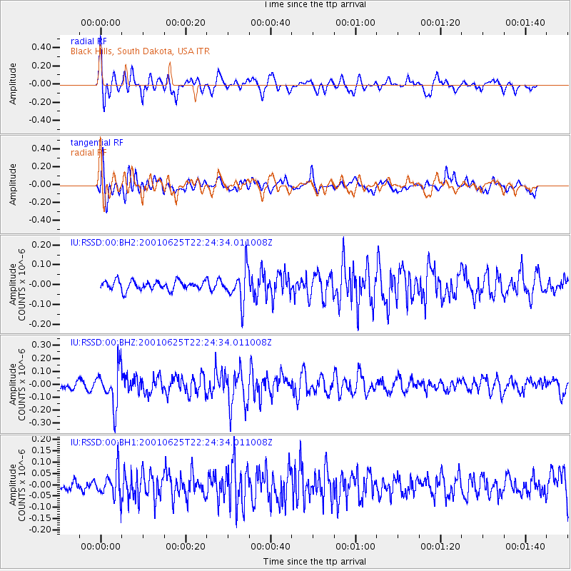
RSSD Black Hills, South Dakota, USA - Earthquake Result Viewer
*The percent match for this event was below the threshold and hence no stack was calculated.
| Earthquake location: |
Near Coast Of Peru |
| Earthquake latitude/longitude: |
-17.6/-70.7 |
| Earthquake time(UTC): |
2001/06/25 (176) 22:14:10 GMT |
| Earthquake Depth: |
74 km |
| Earthquake Magnitude: |
5.5 MW |
| Earthquake Catalog/Contributor: |
NEIC PDE/NEIC PDE-M |
|
| Network: |
IU Global Seismograph Network (GSN - IRIS/USGS) |
| Station: |
RSSD Black Hills, South Dakota, USA |
| Lat/Lon: |
44.12 N/104.04 W |
| Elevation: |
2060 m |
|
| Distance: |
68.6 deg |
| Az: |
334.823 deg |
| Baz: |
145.705 deg |
| Ray Param: |
$rayparam |
*The percent match for this event was below the threshold and hence was not used in the summary stack. |
|
| Radial Match: |
80.281 % |
| Radial Bump: |
400 |
| Transverse Match: |
72.79808 % |
| Transverse Bump: |
400 |
| SOD ConfigId: |
590571 |
| Insert Time: |
2013-09-24 20:58:58.524 +0000 |
| GWidth: |
2.5 |
| Max Bumps: |
400 |
| Tol: |
0.001 |
|
Signal To Noise
| Channel | StoN | STA | LTA |
| IU:RSSD:00:BHZ:20010625T22:24:34.011008Z | 4.5211167 | 1.514004E-7 | 3.3487392E-8 |
| IU:RSSD:00:BH1:20010625T22:24:34.011008Z | 2.2744062 | 6.136446E-8 | 2.698043E-8 |
| IU:RSSD:00:BH2:20010625T22:24:34.011008Z | 3.7406492 | 8.574605E-8 | 2.2922771E-8 |
| Arrivals |
| Ps | |
| PpPs | |
| PsPs/PpSs | |


