You are here: Home > Network List > IU - Global Seismograph Network (GSN - IRIS/USGS) Stations List
> Station RSSD Black Hills, South Dakota, USA > Earthquake Result Viewer
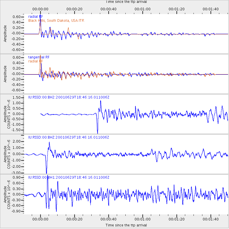
RSSD Black Hills, South Dakota, USA - Earthquake Result Viewer
*The percent match for this event was below the threshold and hence no stack was calculated.
| Earthquake location: |
Southern Bolivia |
| Earthquake latitude/longitude: |
-19.5/-66.3 |
| Earthquake time(UTC): |
2001/06/29 (180) 18:35:51 GMT |
| Earthquake Depth: |
274 km |
| Earthquake Magnitude: |
5.7 MB, 6.1 MW, 6.1 MW |
| Earthquake Catalog/Contributor: |
WHDF/NEIC |
|
| Network: |
IU Global Seismograph Network (GSN - IRIS/USGS) |
| Station: |
RSSD Black Hills, South Dakota, USA |
| Lat/Lon: |
44.12 N/104.04 W |
| Elevation: |
2060 m |
|
| Distance: |
72.2 deg |
| Az: |
332.384 deg |
| Baz: |
142.621 deg |
| Ray Param: |
$rayparam |
*The percent match for this event was below the threshold and hence was not used in the summary stack. |
|
| Radial Match: |
91.45603 % |
| Radial Bump: |
400 |
| Transverse Match: |
80.40543 % |
| Transverse Bump: |
400 |
| SOD ConfigId: |
590571 |
| Insert Time: |
2013-09-24 21:00:22.316 +0000 |
| GWidth: |
2.5 |
| Max Bumps: |
400 |
| Tol: |
0.001 |
|
Signal To Noise
| Channel | StoN | STA | LTA |
| IU:RSSD:00:BHZ:20010629T18:46:16.011006Z | 16.778679 | 9.237388E-7 | 5.5054326E-8 |
| IU:RSSD:00:BH1:20010629T18:46:16.011006Z | 8.110397 | 3.4206832E-7 | 4.2176517E-8 |
| IU:RSSD:00:BH2:20010629T18:46:16.011006Z | 13.756809 | 5.164246E-7 | 3.753956E-8 |
| Arrivals |
| Ps | |
| PpPs | |
| PsPs/PpSs | |


