You are here: Home > Network List > IU - Global Seismograph Network (GSN - IRIS/USGS) Stations List
> Station MIDW Midway Island, USA > Earthquake Result Viewer
MIDW Midway Island, USA - Earthquake Result Viewer
| Earthquake location: |
Fiji Islands Region |
| Earthquake latitude/longitude: |
-21.7/-176.7 |
| Earthquake time(UTC): |
2001/07/04 (185) 07:06:31 GMT |
| Earthquake Depth: |
185 km |
| Earthquake Magnitude: |
5.9 MB, 5.8 MS, 6.5 MW, 6.5 MW |
| Earthquake Catalog/Contributor: |
WHDF/NEIC |
|
| Network: |
IU Global Seismograph Network (GSN - IRIS/USGS) |
| Station: |
MIDW Midway Island, USA |
| Lat/Lon: |
28.22 N/177.37 W |
| Elevation: |
18 m |
|
| Distance: |
49.7 deg |
| Az: |
359.23 deg |
| Baz: |
179.189 deg |
| Ray Param: |
0.06789309 |
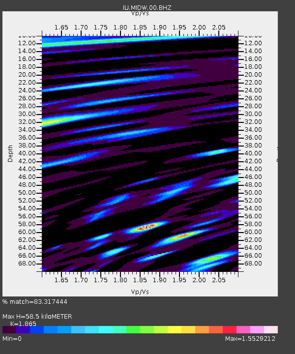
| Estimated Moho Depth: |
58.5 km |
| Estimated Crust Vp/Vs: |
1.87 |
| Assumed Crust Vp: |
4.24 km/s |
| Estimated Crust Vs: |
2.273 km/s |
| Estimated Crust Poisson's Ratio: |
0.30 |
|
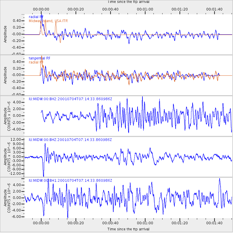
| Radial Match: |
83.317444 % |
| Radial Bump: |
400 |
| Transverse Match: |
77.89508 % |
| Transverse Bump: |
400 |
| SOD ConfigId: |
590571 |
| Insert Time: |
2013-09-24 21:02:57.114 +0000 |
| GWidth: |
2.5 |
| Max Bumps: |
400 |
| Tol: |
0.001 |
|
Signal To Noise
| Channel | StoN | STA | LTA |
| IU:MIDW:00:BHZ:20010704T07:14:33.860986Z | 9.488002 | 5.263401E-6 | 5.547428E-7 |
| IU:MIDW:00:BH1:20010704T07:14:33.860986Z | 3.8470743 | 2.5608829E-6 | 6.6567026E-7 |
| IU:MIDW:00:BH2:20010704T07:14:33.860986Z | 2.6831648 | 2.0975413E-6 | 7.817415E-7 |
| Arrivals |
| Ps | 12 SECOND |
| PpPs | 39 SECOND |
| PsPs/PpSs | 51 SECOND |


