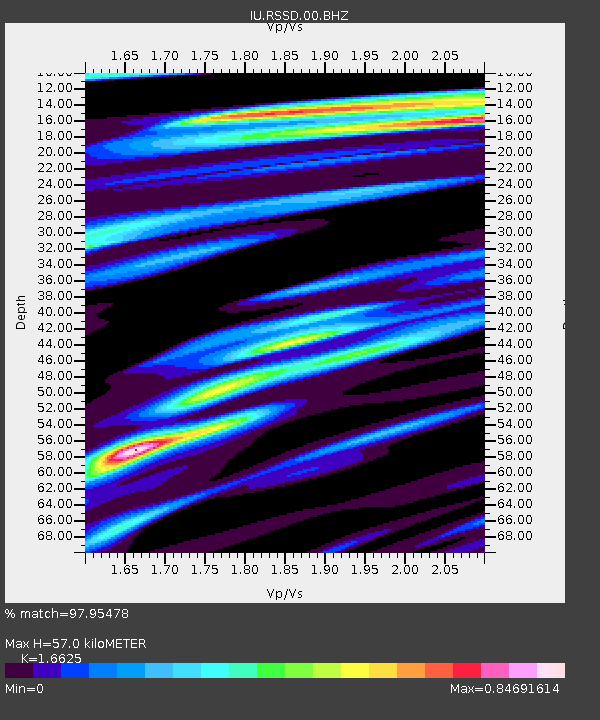
RSSD Black Hills, South Dakota, USA - Earthquake Result Viewer
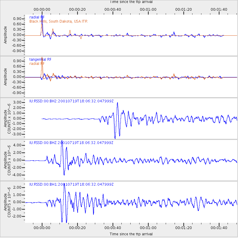
Earthquake location: Kodiak Island Region, Alaska
Earthquake latitude/longitude: 57.2/-151.0
Earthquake time(UTC): 2001/07/19 (200) 18:00:40 GMT
Earthquake Depth: 33 km
Earthquake Magnitude: 5.9 MB, 5.4 MS, 5.9 MW, 5.9 ML
Earthquake Catalog/Contributor: WHDF/NEIC
Network: IU Global Seismograph Network (GSN - IRIS/USGS)
Station: RSSD Black Hills, South Dakota, USA
Lat/Lon: 44.12 N/104.04 W
Elevation: 2060 m
Distance: 31.9 deg
Az: 93.748 deg
Baz: 311.058 deg
Ray Param: 0.07884749
Estimated Moho Depth: 57.0 km
Estimated Crust Vp/Vs: 1.66
Assumed Crust Vp: 6.242 km/s
Estimated Crust Vs: 3.755 km/s
Estimated Crust Poisson's Ratio: 0.22
Radial Match: 97.95478 %
Radial Bump: 268
Transverse Match: 91.29804 %
Transverse Bump: 400
SOD ConfigId: 590571
Insert Time: 2013-09-24 21:07:15.816 +0000
GWidth: 2.5
Max Bumps: 400
Tol: 0.001

Signal To Noise

ChannelStoNSTALTA
IU:RSSD:00:BHZ:20010719T18:06:32.047999Z10.3176133.7765557E-73.6602998E-8
IU:RSSD:00:BH1:20010719T18:06:32.047999Z4.168841.8201648E-74.3661178E-8
IU:RSSD:00:BH2:20010719T18:06:32.047999Z5.97506432.3742754E-73.97364E-8
Arrivals
Ps6.6 SECOND
PpPs22 SECOND
PsPs/PpSs29 SECOND