You are here: Home > Network List > IU - Global Seismograph Network (GSN - IRIS/USGS) Stations List
> Station RSSD Black Hills, South Dakota, USA > Earthquake Result Viewer
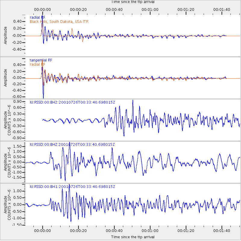
RSSD Black Hills, South Dakota, USA - Earthquake Result Viewer
*The percent match for this event was below the threshold and hence no stack was calculated.
| Earthquake location: |
Aegean Sea |
| Earthquake latitude/longitude: |
39.1/24.2 |
| Earthquake time(UTC): |
2001/07/26 (207) 00:21:36 GMT |
| Earthquake Depth: |
10 km |
| Earthquake Magnitude: |
6.0 MB, 6.6 MS, 7.0 ME, 6.1 ML |
| Earthquake Catalog/Contributor: |
WHDF/NEIC |
|
| Network: |
IU Global Seismograph Network (GSN - IRIS/USGS) |
| Station: |
RSSD Black Hills, South Dakota, USA |
| Lat/Lon: |
44.12 N/104.04 W |
| Elevation: |
2060 m |
|
| Distance: |
85.0 deg |
| Az: |
325.42 deg |
| Baz: |
37.846 deg |
| Ray Param: |
$rayparam |
*The percent match for this event was below the threshold and hence was not used in the summary stack. |
|
| Radial Match: |
91.56776 % |
| Radial Bump: |
400 |
| Transverse Match: |
88.66547 % |
| Transverse Bump: |
400 |
| SOD ConfigId: |
590571 |
| Insert Time: |
2013-09-24 21:09:58.535 +0000 |
| GWidth: |
2.5 |
| Max Bumps: |
400 |
| Tol: |
0.001 |
|
Signal To Noise
| Channel | StoN | STA | LTA |
| IU:RSSD:00:BHZ:20010726T00:33:40.698015Z | 4.7379174 | 3.2547686E-7 | 6.869619E-8 |
| IU:RSSD:00:BH1:20010726T00:33:40.698015Z | 1.9642673 | 1.4032437E-7 | 7.1438535E-8 |
| IU:RSSD:00:BH2:20010726T00:33:40.698015Z | 1.4096249 | 8.3910514E-8 | 5.9526837E-8 |
| Arrivals |
| Ps | |
| PpPs | |
| PsPs/PpSs | |


