You are here: Home > Network List > IU - Global Seismograph Network (GSN - IRIS/USGS) Stations List
> Station RSSD Black Hills, South Dakota, USA > Earthquake Result Viewer
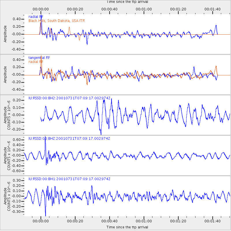
RSSD Black Hills, South Dakota, USA - Earthquake Result Viewer
*The percent match for this event was below the threshold and hence no stack was calculated.
| Earthquake location: |
Fiji Islands Region |
| Earthquake latitude/longitude: |
-17.7/-178.8 |
| Earthquake time(UTC): |
2001/07/31 (212) 06:57:40 GMT |
| Earthquake Depth: |
564 km |
| Earthquake Magnitude: |
5.5 MW, 5.5 MW |
| Earthquake Catalog/Contributor: |
NEIC PDE/NEIC PDE-M |
|
| Network: |
IU Global Seismograph Network (GSN - IRIS/USGS) |
| Station: |
RSSD Black Hills, South Dakota, USA |
| Lat/Lon: |
44.12 N/104.04 W |
| Elevation: |
2060 m |
|
| Distance: |
91.7 deg |
| Az: |
44.05 deg |
| Baz: |
246.969 deg |
| Ray Param: |
$rayparam |
*The percent match for this event was below the threshold and hence was not used in the summary stack. |
|
| Radial Match: |
68.544495 % |
| Radial Bump: |
400 |
| Transverse Match: |
47.998207 % |
| Transverse Bump: |
375 |
| SOD ConfigId: |
590571 |
| Insert Time: |
2013-09-24 21:10:52.563 +0000 |
| GWidth: |
2.5 |
| Max Bumps: |
400 |
| Tol: |
0.001 |
|
Signal To Noise
| Channel | StoN | STA | LTA |
| IU:RSSD:00:BHZ:20010731T07:09:17.002974Z | 3.3429523 | 2.2408763E-7 | 6.703285E-8 |
| IU:RSSD:00:BH1:20010731T07:09:17.002974Z | 3.1822832 | 1.3850104E-7 | 4.3522533E-8 |
| IU:RSSD:00:BH2:20010731T07:09:17.002974Z | 1.7976369 | 1.0530973E-7 | 5.8582316E-8 |
| Arrivals |
| Ps | |
| PpPs | |
| PsPs/PpSs | |


