You are here: Home > Network List > II - Global Seismograph Network (GSN - IRIS/IDA) Stations List
> Station MBAR Mbarara, Uganda > Earthquake Result Viewer
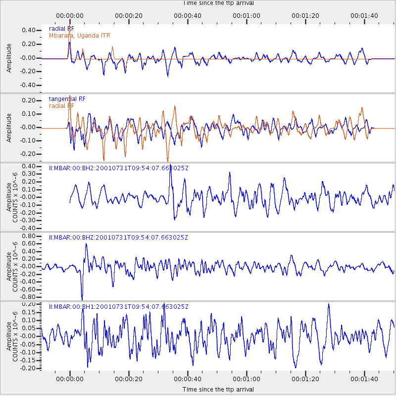
MBAR Mbarara, Uganda - Earthquake Result Viewer
*The percent match for this event was below the threshold and hence no stack was calculated.
| Earthquake location: |
Southern Sumatra, Indonesia |
| Earthquake latitude/longitude: |
-5.3/103.3 |
| Earthquake time(UTC): |
2001/07/31 (212) 09:43:14 GMT |
| Earthquake Depth: |
33 km |
| Earthquake Magnitude: |
5.6 MW, 5.5 MB, 5.7 MW |
| Earthquake Catalog/Contributor: |
NEIC PDE/NEIC PDE-M |
|
| Network: |
II Global Seismograph Network (GSN - IRIS/IDA) |
| Station: |
MBAR Mbarara, Uganda |
| Lat/Lon: |
0.60 S/30.74 E |
| Elevation: |
1390 m |
|
| Distance: |
72.6 deg |
| Az: |
271.018 deg |
| Baz: |
95.31 deg |
| Ray Param: |
$rayparam |
*The percent match for this event was below the threshold and hence was not used in the summary stack. |
|
| Radial Match: |
53.77575 % |
| Radial Bump: |
370 |
| Transverse Match: |
56.104595 % |
| Transverse Bump: |
400 |
| SOD ConfigId: |
590571 |
| Insert Time: |
2013-09-24 21:10:58.574 +0000 |
| GWidth: |
2.5 |
| Max Bumps: |
400 |
| Tol: |
0.001 |
|
Signal To Noise
| Channel | StoN | STA | LTA |
| II:MBAR:00:BHZ:20010731T09:54:07.663025Z | 3.5976326 | 2.557595E-7 | 7.109105E-8 |
| II:MBAR:00:BH1:20010731T09:54:07.663025Z | 0.9815455 | 6.8002414E-8 | 6.9280965E-8 |
| II:MBAR:00:BH2:20010731T09:54:07.663025Z | 1.6752486 | 1.3378136E-7 | 7.985762E-8 |
| Arrivals |
| Ps | |
| PpPs | |
| PsPs/PpSs | |


