You are here: Home > Network List > II - Global Seismograph Network (GSN - IRIS/IDA) Stations List
> Station MBAR Mbarara, Uganda > Earthquake Result Viewer
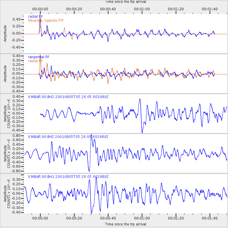
MBAR Mbarara, Uganda - Earthquake Result Viewer
*The percent match for this event was below the threshold and hence no stack was calculated.
| Earthquake location: |
Andaman Islands, India Region |
| Earthquake latitude/longitude: |
12.2/93.4 |
| Earthquake time(UTC): |
2001/08/05 (217) 05:16:16 GMT |
| Earthquake Depth: |
96 km |
| Earthquake Magnitude: |
5.4 MB, 5.2 MS, 6.0 MW, 5.9 MW |
| Earthquake Catalog/Contributor: |
WHDF/NEIC |
|
| Network: |
II Global Seismograph Network (GSN - IRIS/IDA) |
| Station: |
MBAR Mbarara, Uganda |
| Lat/Lon: |
0.60 S/30.74 E |
| Elevation: |
1390 m |
|
| Distance: |
63.4 deg |
| Az: |
263.13 deg |
| Baz: |
76.085 deg |
| Ray Param: |
$rayparam |
*The percent match for this event was below the threshold and hence was not used in the summary stack. |
|
| Radial Match: |
66.80902 % |
| Radial Bump: |
305 |
| Transverse Match: |
57.32636 % |
| Transverse Bump: |
400 |
| SOD ConfigId: |
590571 |
| Insert Time: |
2013-09-24 21:13:20.781 +0000 |
| GWidth: |
2.5 |
| Max Bumps: |
400 |
| Tol: |
0.001 |
|
Signal To Noise
| Channel | StoN | STA | LTA |
| II:MBAR:00:BHZ:20010805T05:26:05.603989Z | 1.7513407 | 1.230348E-7 | 7.025177E-8 |
| II:MBAR:00:BH1:20010805T05:26:05.603989Z | 0.56585443 | 4.5297927E-8 | 8.005227E-8 |
| II:MBAR:00:BH2:20010805T05:26:05.603989Z | 0.40889767 | 3.1580093E-8 | 7.7232265E-8 |
| Arrivals |
| Ps | |
| PpPs | |
| PsPs/PpSs | |


