You are here: Home > Network List > IU - Global Seismograph Network (GSN - IRIS/USGS) Stations List
> Station RSSD Black Hills, South Dakota, USA > Earthquake Result Viewer
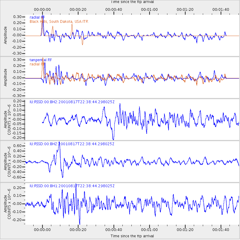
RSSD Black Hills, South Dakota, USA - Earthquake Result Viewer
*The percent match for this event was below the threshold and hence no stack was calculated.
| Earthquake location: |
Ryukyu Islands, Japan |
| Earthquake latitude/longitude: |
25.7/126.2 |
| Earthquake time(UTC): |
2001/08/17 (229) 22:25:49 GMT |
| Earthquake Depth: |
33 km |
| Earthquake Magnitude: |
5.6 MB, 5.6 MS, 5.9 MW, 5.9 MW |
| Earthquake Catalog/Contributor: |
WHDF/NEIC |
|
| Network: |
IU Global Seismograph Network (GSN - IRIS/USGS) |
| Station: |
RSSD Black Hills, South Dakota, USA |
| Lat/Lon: |
44.12 N/104.04 W |
| Elevation: |
2060 m |
|
| Distance: |
96.6 deg |
| Az: |
33.868 deg |
| Baz: |
315.746 deg |
| Ray Param: |
$rayparam |
*The percent match for this event was below the threshold and hence was not used in the summary stack. |
|
| Radial Match: |
76.98327 % |
| Radial Bump: |
400 |
| Transverse Match: |
67.58569 % |
| Transverse Bump: |
400 |
| SOD ConfigId: |
590571 |
| Insert Time: |
2013-09-24 21:19:18.496 +0000 |
| GWidth: |
2.5 |
| Max Bumps: |
400 |
| Tol: |
0.001 |
|
Signal To Noise
| Channel | StoN | STA | LTA |
| IU:RSSD:00:BHZ:20010817T22:38:44.298025Z | 3.7783585 | 1.4007692E-7 | 3.7073487E-8 |
| IU:RSSD:00:BH1:20010817T22:38:44.298025Z | 1.3217728 | 4.9651568E-8 | 3.7564373E-8 |
| IU:RSSD:00:BH2:20010817T22:38:44.298025Z | 1.650205 | 5.5094652E-8 | 3.3386552E-8 |
| Arrivals |
| Ps | |
| PpPs | |
| PsPs/PpSs | |


