You are here: Home > Network List > IU - Global Seismograph Network (GSN - IRIS/USGS) Stations List
> Station JOHN Johnston Island, USA > Earthquake Result Viewer
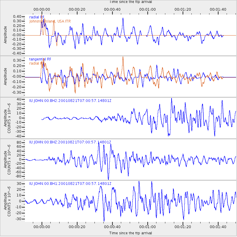
JOHN Johnston Island, USA - Earthquake Result Viewer
*The percent match for this event was below the threshold and hence no stack was calculated.
| Earthquake location: |
East Of North Island, N.Z. |
| Earthquake latitude/longitude: |
-36.8/-179.6 |
| Earthquake time(UTC): |
2001/08/21 (233) 06:52:06 GMT |
| Earthquake Depth: |
33 km |
| Earthquake Magnitude: |
6.4 MB, 7.1 MS, 7.2 ME, 7.0 ML |
| Earthquake Catalog/Contributor: |
WHDF/NEIC |
|
| Network: |
IU Global Seismograph Network (GSN - IRIS/USGS) |
| Station: |
JOHN Johnston Island, USA |
| Lat/Lon: |
16.73 N/169.53 W |
| Elevation: |
2.0 m |
|
| Distance: |
54.1 deg |
| Az: |
11.909 deg |
| Baz: |
189.952 deg |
| Ray Param: |
$rayparam |
*The percent match for this event was below the threshold and hence was not used in the summary stack. |
|
| Radial Match: |
91.04908 % |
| Radial Bump: |
400 |
| Transverse Match: |
85.26914 % |
| Transverse Bump: |
400 |
| SOD ConfigId: |
590571 |
| Insert Time: |
2013-09-24 21:19:44.207 +0000 |
| GWidth: |
2.5 |
| Max Bumps: |
400 |
| Tol: |
0.001 |
|
Signal To Noise
| Channel | StoN | STA | LTA |
| IU:JOHN:00:BHZ:20010821T07:00:57.14801Z | 3.2010565 | 4.483692E-6 | 1.4006913E-6 |
| IU:JOHN:00:BH1:20010821T07:00:57.14801Z | 1.7541814 | 2.6378946E-6 | 1.5037753E-6 |
| IU:JOHN:00:BH2:20010821T07:00:57.14801Z | 2.3304427 | 3.6260244E-6 | 1.555938E-6 |
| Arrivals |
| Ps | |
| PpPs | |
| PsPs/PpSs | |


