You are here: Home > Network List > IU - Global Seismograph Network (GSN - IRIS/USGS) Stations List
> Station JOHN Johnston Island, USA > Earthquake Result Viewer
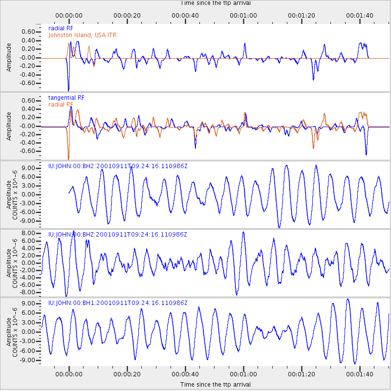
JOHN Johnston Island, USA - Earthquake Result Viewer
*The percent match for this event was below the threshold and hence no stack was calculated.
| Earthquake location: |
Guatemala |
| Earthquake latitude/longitude: |
15.0/-91.6 |
| Earthquake time(UTC): |
2001/09/11 (254) 09:13:26 GMT |
| Earthquake Depth: |
161 km |
| Earthquake Magnitude: |
5.6 MW, 5.6 MW |
| Earthquake Catalog/Contributor: |
NEIC PDE/NEIC PDE-M |
|
| Network: |
IU Global Seismograph Network (GSN - IRIS/USGS) |
| Station: |
JOHN Johnston Island, USA |
| Lat/Lon: |
16.73 N/169.53 W |
| Elevation: |
2.0 m |
|
| Distance: |
74.5 deg |
| Az: |
283.508 deg |
| Baz: |
78.71 deg |
| Ray Param: |
$rayparam |
*The percent match for this event was below the threshold and hence was not used in the summary stack. |
|
| Radial Match: |
47.589966 % |
| Radial Bump: |
400 |
| Transverse Match: |
36.926025 % |
| Transverse Bump: |
296 |
| SOD ConfigId: |
590571 |
| Insert Time: |
2013-09-24 21:25:06.471 +0000 |
| GWidth: |
2.5 |
| Max Bumps: |
400 |
| Tol: |
0.001 |
|
Signal To Noise
| Channel | StoN | STA | LTA |
| IU:JOHN:00:BHZ:20010911T09:24:16.110986Z | 1.3882546 | 5.77214E-6 | 4.1578396E-6 |
| IU:JOHN:00:BH1:20010911T09:24:16.110986Z | 1.5039375 | 4.6725827E-6 | 3.1068996E-6 |
| IU:JOHN:00:BH2:20010911T09:24:16.110986Z | 0.6053778 | 3.2379412E-6 | 5.3486287E-6 |
| Arrivals |
| Ps | |
| PpPs | |
| PsPs/PpSs | |


