You are here: Home > Network List > IU - Global Seismograph Network (GSN - IRIS/USGS) Stations List
> Station POHA Pohakuloa, Hawaii, USA > Earthquake Result Viewer
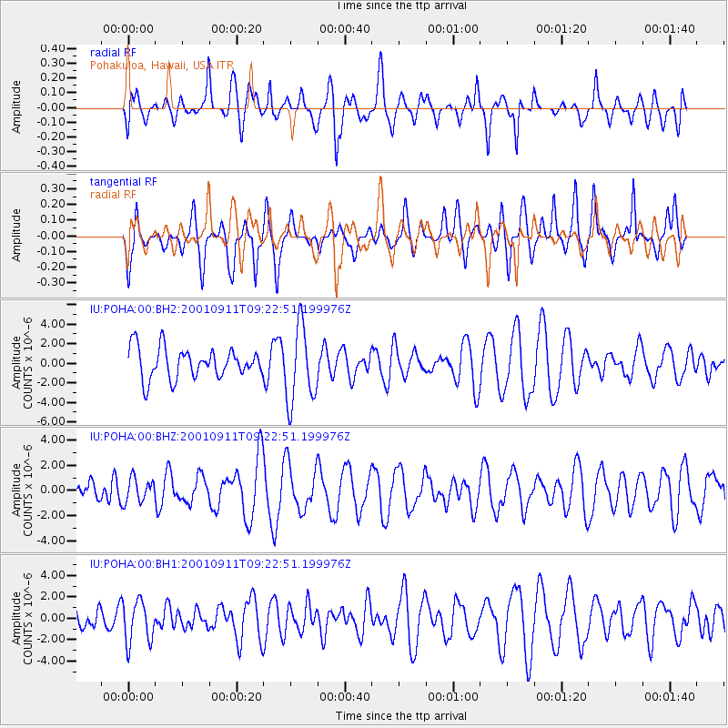
POHA Pohakuloa, Hawaii, USA - Earthquake Result Viewer
*The percent match for this event was below the threshold and hence no stack was calculated.
| Earthquake location: |
Guatemala |
| Earthquake latitude/longitude: |
15.0/-91.6 |
| Earthquake time(UTC): |
2001/09/11 (254) 09:13:26 GMT |
| Earthquake Depth: |
161 km |
| Earthquake Magnitude: |
5.6 MW, 5.6 MW |
| Earthquake Catalog/Contributor: |
NEIC PDE/NEIC PDE-M |
|
| Network: |
IU Global Seismograph Network (GSN - IRIS/USGS) |
| Station: |
POHA Pohakuloa, Hawaii, USA |
| Lat/Lon: |
19.76 N/155.53 W |
| Elevation: |
1967 m |
|
| Distance: |
60.9 deg |
| Az: |
284.473 deg |
| Baz: |
83.455 deg |
| Ray Param: |
$rayparam |
*The percent match for this event was below the threshold and hence was not used in the summary stack. |
|
| Radial Match: |
60.215763 % |
| Radial Bump: |
400 |
| Transverse Match: |
37.313778 % |
| Transverse Bump: |
400 |
| SOD ConfigId: |
590571 |
| Insert Time: |
2013-09-24 21:25:10.427 +0000 |
| GWidth: |
2.5 |
| Max Bumps: |
400 |
| Tol: |
0.001 |
|
Signal To Noise
| Channel | StoN | STA | LTA |
| IU:POHA:00:BHZ:20010911T09:22:51.199976Z | 0.831351 | 9.2990774E-7 | 1.1185501E-6 |
| IU:POHA:00:BH1:20010911T09:22:51.199976Z | 1.4521965 | 1.9888043E-6 | 1.3695146E-6 |
| IU:POHA:00:BH2:20010911T09:22:51.199976Z | 2.5897484 | 3.9879133E-6 | 1.5398845E-6 |
| Arrivals |
| Ps | |
| PpPs | |
| PsPs/PpSs | |


