You are here: Home > Network List > IU - Global Seismograph Network (GSN - IRIS/USGS) Stations List
> Station RSSD Black Hills, South Dakota, USA > Earthquake Result Viewer
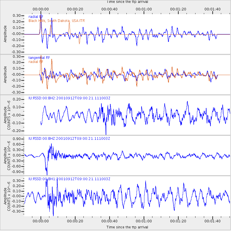
RSSD Black Hills, South Dakota, USA - Earthquake Result Viewer
*The percent match for this event was below the threshold and hence no stack was calculated.
| Earthquake location: |
Fiji Islands Region |
| Earthquake latitude/longitude: |
-21.0/-179.1 |
| Earthquake time(UTC): |
2001/09/12 (255) 08:48:37 GMT |
| Earthquake Depth: |
608 km |
| Earthquake Magnitude: |
5.7 MB, 6.5 MW, 6.4 MW |
| Earthquake Catalog/Contributor: |
WHDF/NEIC |
|
| Network: |
IU Global Seismograph Network (GSN - IRIS/USGS) |
| Station: |
RSSD Black Hills, South Dakota, USA |
| Lat/Lon: |
44.12 N/104.04 W |
| Elevation: |
2060 m |
|
| Distance: |
94.2 deg |
| Az: |
44.251 deg |
| Baz: |
244.871 deg |
| Ray Param: |
$rayparam |
*The percent match for this event was below the threshold and hence was not used in the summary stack. |
|
| Radial Match: |
47.700775 % |
| Radial Bump: |
400 |
| Transverse Match: |
52.5375 % |
| Transverse Bump: |
400 |
| SOD ConfigId: |
590571 |
| Insert Time: |
2013-09-24 21:26:01.489 +0000 |
| GWidth: |
2.5 |
| Max Bumps: |
400 |
| Tol: |
0.001 |
|
Signal To Noise
| Channel | StoN | STA | LTA |
| IU:RSSD:00:BHZ:20010912T09:00:21.111003Z | 5.4218903 | 3.6237333E-7 | 6.6835234E-8 |
| IU:RSSD:00:BH1:20010912T09:00:21.111003Z | 1.6256464 | 1.3859353E-7 | 8.525441E-8 |
| IU:RSSD:00:BH2:20010912T09:00:21.111003Z | 0.8852222 | 4.629532E-8 | 5.2297963E-8 |
| Arrivals |
| Ps | |
| PpPs | |
| PsPs/PpSs | |


