You are here: Home > Network List > IU - Global Seismograph Network (GSN - IRIS/USGS) Stations List
> Station RSSD Black Hills, South Dakota, USA > Earthquake Result Viewer
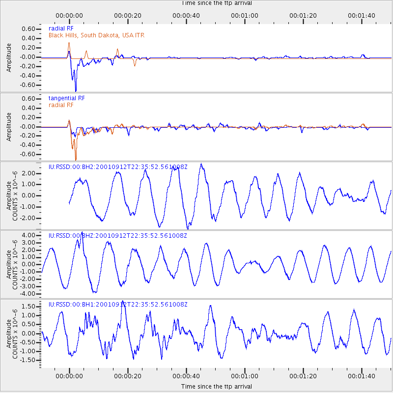
RSSD Black Hills, South Dakota, USA - Earthquake Result Viewer
*The percent match for this event was below the threshold and hence no stack was calculated.
| Earthquake location: |
Bonin Islands, Japan Region |
| Earthquake latitude/longitude: |
27.7/141.9 |
| Earthquake time(UTC): |
2001/09/12 (255) 22:23:44 GMT |
| Earthquake Depth: |
33 km |
| Earthquake Magnitude: |
6.0 MB, 5.1 MS, 5.7 MW, 5.7 MW |
| Earthquake Catalog/Contributor: |
WHDF/NEIC |
|
| Network: |
IU Global Seismograph Network (GSN - IRIS/USGS) |
| Station: |
RSSD Black Hills, South Dakota, USA |
| Lat/Lon: |
44.12 N/104.04 W |
| Elevation: |
2060 m |
|
| Distance: |
86.5 deg |
| Az: |
41.213 deg |
| Baz: |
305.787 deg |
| Ray Param: |
$rayparam |
*The percent match for this event was below the threshold and hence was not used in the summary stack. |
|
| Radial Match: |
96.71129 % |
| Radial Bump: |
299 |
| Transverse Match: |
63.08951 % |
| Transverse Bump: |
400 |
| SOD ConfigId: |
590571 |
| Insert Time: |
2013-09-24 21:26:36.954 +0000 |
| GWidth: |
2.5 |
| Max Bumps: |
400 |
| Tol: |
0.001 |
|
Signal To Noise
| Channel | StoN | STA | LTA |
| IU:RSSD:00:BHZ:20010912T22:35:52.561008Z | 1.4939672 | 2.6493892E-6 | 1.7733919E-6 |
| IU:RSSD:00:BH1:20010912T22:35:52.561008Z | 0.90699416 | 8.0622317E-7 | 8.888956E-7 |
| IU:RSSD:00:BH2:20010912T22:35:52.561008Z | 1.3379215 | 1.7945345E-6 | 1.3412854E-6 |
| Arrivals |
| Ps | |
| PpPs | |
| PsPs/PpSs | |


