You are here: Home > Network List > II - Global Seismograph Network (GSN - IRIS/IDA) Stations List
> Station MBAR Mbarara, Uganda > Earthquake Result Viewer
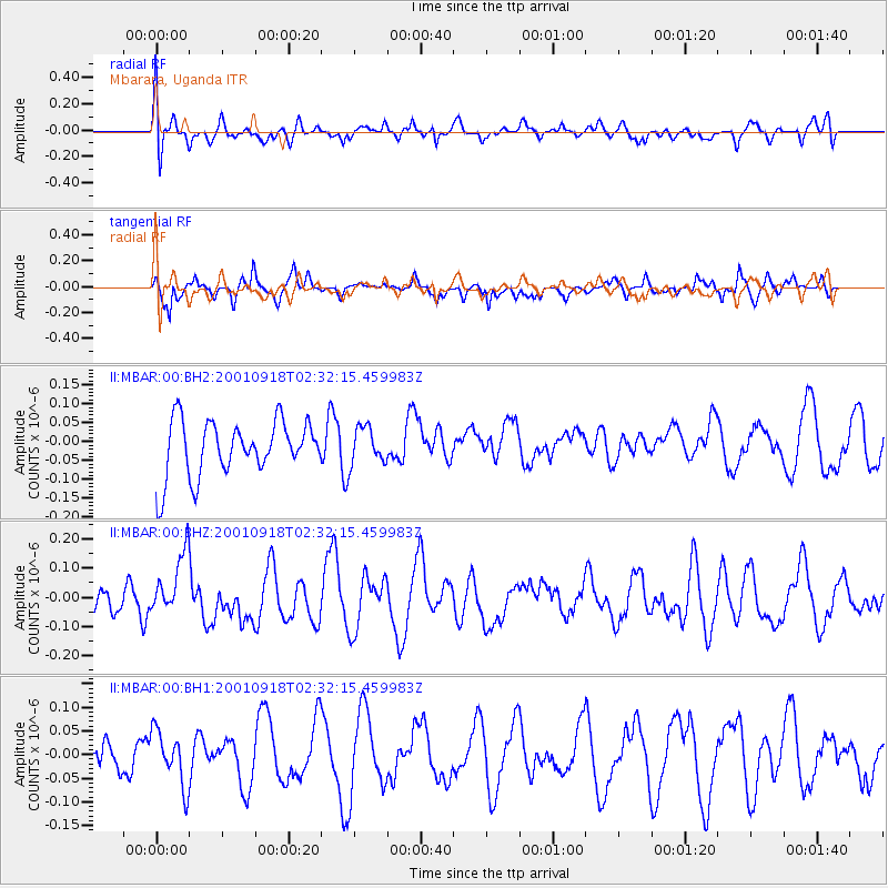
MBAR Mbarara, Uganda - Earthquake Result Viewer
*The percent match for this event was below the threshold and hence no stack was calculated.
| Earthquake location: |
Banda Sea |
| Earthquake latitude/longitude: |
-7.5/127.7 |
| Earthquake time(UTC): |
2001/09/18 (261) 02:19:30 GMT |
| Earthquake Depth: |
132 km |
| Earthquake Magnitude: |
5.6 MB, 5.1 MS, 6.0 MW, 6.0 MW |
| Earthquake Catalog/Contributor: |
WHDF/NEIC |
|
| Network: |
II Global Seismograph Network (GSN - IRIS/IDA) |
| Station: |
MBAR Mbarara, Uganda |
| Lat/Lon: |
0.60 S/30.74 E |
| Elevation: |
1390 m |
|
| Distance: |
96.9 deg |
| Az: |
268.49 deg |
| Baz: |
97.583 deg |
| Ray Param: |
$rayparam |
*The percent match for this event was below the threshold and hence was not used in the summary stack. |
|
| Radial Match: |
41.21345 % |
| Radial Bump: |
400 |
| Transverse Match: |
69.32762 % |
| Transverse Bump: |
400 |
| SOD ConfigId: |
590571 |
| Insert Time: |
2013-09-24 21:29:08.052 +0000 |
| GWidth: |
2.5 |
| Max Bumps: |
400 |
| Tol: |
0.001 |
|
Signal To Noise
| Channel | StoN | STA | LTA |
| II:MBAR:00:BHZ:20010918T02:32:15.459983Z | 1.6108408 | 1.0525361E-7 | 6.534079E-8 |
| II:MBAR:00:BH1:20010918T02:32:15.459983Z | 1.2541845 | 6.0064146E-8 | 4.7890996E-8 |
| II:MBAR:00:BH2:20010918T02:32:15.459983Z | 0.67511684 | 4.900585E-8 | 7.258869E-8 |
| Arrivals |
| Ps | |
| PpPs | |
| PsPs/PpSs | |


