You are here: Home > Network List > IU - Global Seismograph Network (GSN - IRIS/USGS) Stations List
> Station RSSD Black Hills, South Dakota, USA > Earthquake Result Viewer
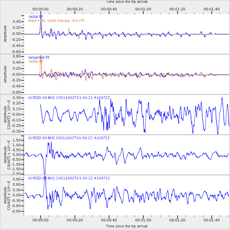
RSSD Black Hills, South Dakota, USA - Earthquake Result Viewer
*The percent match for this event was below the threshold and hence no stack was calculated.
| Earthquake location: |
Tonga Islands |
| Earthquake latitude/longitude: |
-16.2/-173.8 |
| Earthquake time(UTC): |
2001/10/02 (275) 00:48:18 GMT |
| Earthquake Depth: |
107 km |
| Earthquake Magnitude: |
5.8 MB, 6.2 MW, 6.1 MW |
| Earthquake Catalog/Contributor: |
WHDF/NEIC |
|
| Network: |
IU Global Seismograph Network (GSN - IRIS/USGS) |
| Station: |
RSSD Black Hills, South Dakota, USA |
| Lat/Lon: |
44.12 N/104.04 W |
| Elevation: |
2060 m |
|
| Distance: |
87.3 deg |
| Az: |
42.578 deg |
| Baz: |
244.512 deg |
| Ray Param: |
$rayparam |
*The percent match for this event was below the threshold and hence was not used in the summary stack. |
|
| Radial Match: |
78.62534 % |
| Radial Bump: |
352 |
| Transverse Match: |
69.5853 % |
| Transverse Bump: |
400 |
| SOD ConfigId: |
590571 |
| Insert Time: |
2013-09-24 21:33:38.655 +0000 |
| GWidth: |
2.5 |
| Max Bumps: |
400 |
| Tol: |
0.001 |
|
Signal To Noise
| Channel | StoN | STA | LTA |
| IU:RSSD:00:BHZ:20011002T01:00:22.410972Z | 7.7501125 | 9.396597E-7 | 1.2124464E-7 |
| IU:RSSD:00:BH1:20011002T01:00:22.410972Z | 5.7396283 | 5.0350855E-7 | 8.7724935E-8 |
| IU:RSSD:00:BH2:20011002T01:00:22.410972Z | 1.4130818 | 1.0368865E-7 | 7.337767E-8 |
| Arrivals |
| Ps | |
| PpPs | |
| PsPs/PpSs | |


