You are here: Home > Network List > IU - Global Seismograph Network (GSN - IRIS/USGS) Stations List
> Station JOHN Johnston Island, USA > Earthquake Result Viewer
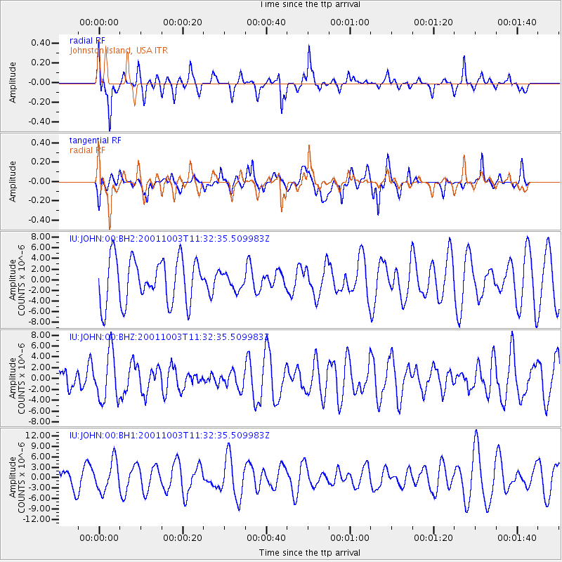
JOHN Johnston Island, USA - Earthquake Result Viewer
*The percent match for this event was below the threshold and hence no stack was calculated.
| Earthquake location: |
Irian Jaya, Indonesia |
| Earthquake latitude/longitude: |
-3.5/139.7 |
| Earthquake time(UTC): |
2001/10/03 (276) 11:23:42 GMT |
| Earthquake Depth: |
10 km |
| Earthquake Magnitude: |
5.7 MW |
| Earthquake Catalog/Contributor: |
NEIC PDE/NEIC PDE-M |
|
| Network: |
IU Global Seismograph Network (GSN - IRIS/USGS) |
| Station: |
JOHN Johnston Island, USA |
| Lat/Lon: |
16.73 N/169.53 W |
| Elevation: |
2.0 m |
|
| Distance: |
54.0 deg |
| Az: |
66.517 deg |
| Baz: |
252.831 deg |
| Ray Param: |
$rayparam |
*The percent match for this event was below the threshold and hence was not used in the summary stack. |
|
| Radial Match: |
38.360447 % |
| Radial Bump: |
318 |
| Transverse Match: |
50.35356 % |
| Transverse Bump: |
400 |
| SOD ConfigId: |
590571 |
| Insert Time: |
2013-09-24 21:34:25.960 +0000 |
| GWidth: |
2.5 |
| Max Bumps: |
400 |
| Tol: |
0.001 |
|
Signal To Noise
| Channel | StoN | STA | LTA |
| IU:JOHN:00:BHZ:20011003T11:32:35.509983Z | 2.5216532 | 4.5368793E-6 | 1.7991687E-6 |
| IU:JOHN:00:BH1:20011003T11:32:35.509983Z | 1.5417491 | 4.433886E-6 | 2.8758802E-6 |
| IU:JOHN:00:BH2:20011003T11:32:35.509983Z | 0.34853402 | 1.4747325E-6 | 4.231244E-6 |
| Arrivals |
| Ps | |
| PpPs | |
| PsPs/PpSs | |


