You are here: Home > Network List > IU - Global Seismograph Network (GSN - IRIS/USGS) Stations List
> Station RSSD Black Hills, South Dakota, USA > Earthquake Result Viewer
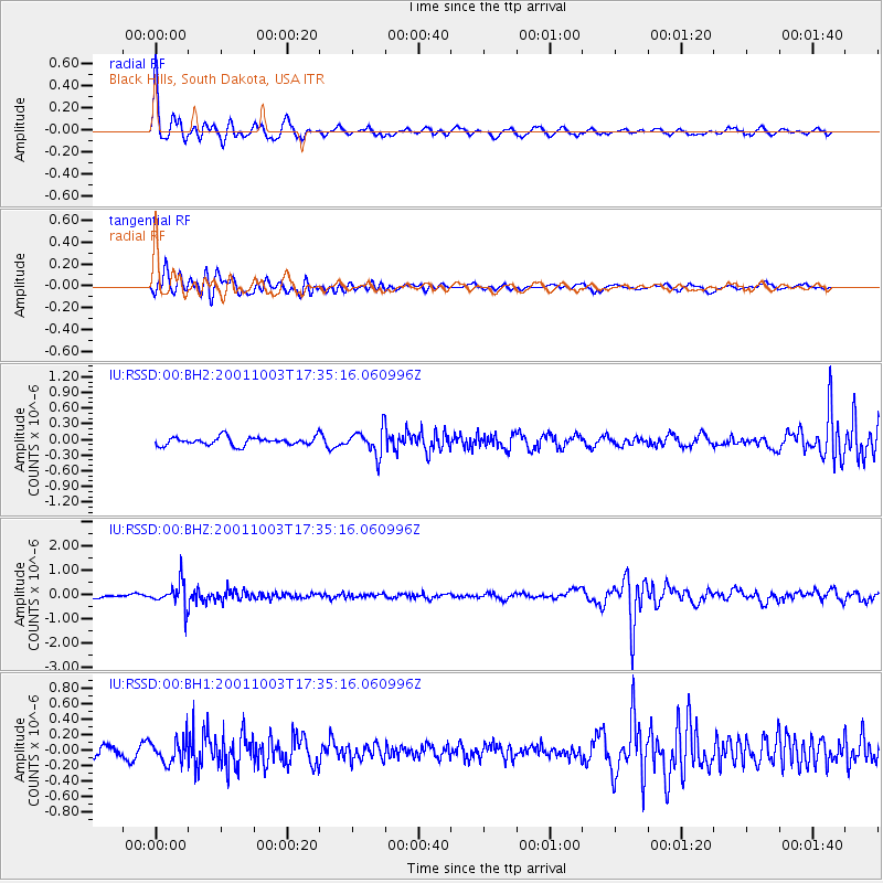
RSSD Black Hills, South Dakota, USA - Earthquake Result Viewer
*The percent match for this event was below the threshold and hence no stack was calculated.
| Earthquake location: |
Northwest Of Kuril Islands |
| Earthquake latitude/longitude: |
47.1/148.6 |
| Earthquake time(UTC): |
2001/10/03 (276) 17:25:12 GMT |
| Earthquake Depth: |
284 km |
| Earthquake Magnitude: |
5.6 MB, 5.9 MW, 5.9 MW |
| Earthquake Catalog/Contributor: |
WHDF/NEIC |
|
| Network: |
IU Global Seismograph Network (GSN - IRIS/USGS) |
| Station: |
RSSD Black Hills, South Dakota, USA |
| Lat/Lon: |
44.12 N/104.04 W |
| Elevation: |
2060 m |
|
| Distance: |
68.9 deg |
| Az: |
47.464 deg |
| Baz: |
315.634 deg |
| Ray Param: |
$rayparam |
*The percent match for this event was below the threshold and hence was not used in the summary stack. |
|
| Radial Match: |
79.55074 % |
| Radial Bump: |
323 |
| Transverse Match: |
60.246426 % |
| Transverse Bump: |
400 |
| SOD ConfigId: |
590571 |
| Insert Time: |
2013-09-24 21:34:49.501 +0000 |
| GWidth: |
2.5 |
| Max Bumps: |
400 |
| Tol: |
0.001 |
|
Signal To Noise
| Channel | StoN | STA | LTA |
| IU:RSSD:00:BHZ:20011003T17:35:16.060996Z | 5.260818 | 4.929851E-7 | 9.370884E-8 |
| IU:RSSD:00:BH1:20011003T17:35:16.060996Z | 2.0831952 | 1.5490907E-7 | 7.436128E-8 |
| IU:RSSD:00:BH2:20011003T17:35:16.060996Z | 3.0775347 | 2.3961712E-7 | 7.7860086E-8 |
| Arrivals |
| Ps | |
| PpPs | |
| PsPs/PpSs | |


