You are here: Home > Network List > IU - Global Seismograph Network (GSN - IRIS/USGS) Stations List
> Station RSSD Black Hills, South Dakota, USA > Earthquake Result Viewer
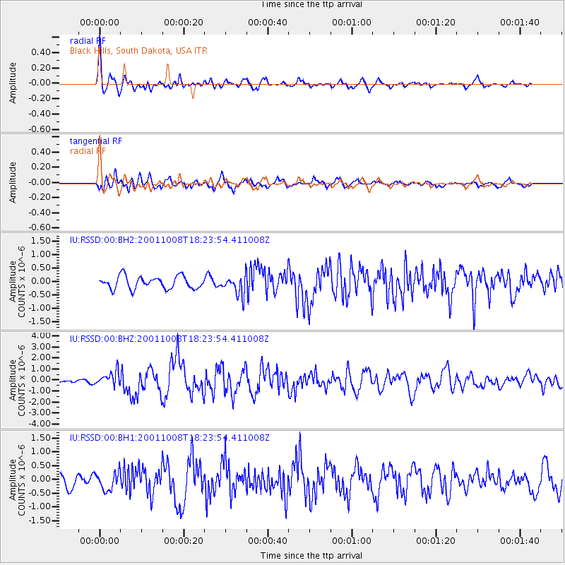
RSSD Black Hills, South Dakota, USA - Earthquake Result Viewer
*The percent match for this event was below the threshold and hence no stack was calculated.
| Earthquake location: |
Off East Coast Of Kamchatka |
| Earthquake latitude/longitude: |
52.6/160.3 |
| Earthquake time(UTC): |
2001/10/08 (281) 18:14:26 GMT |
| Earthquake Depth: |
48 km |
| Earthquake Magnitude: |
5.9 MB, 6.4 MS, 6.5 MW, 6.4 MW |
| Earthquake Catalog/Contributor: |
WHDF/NEIC |
|
| Network: |
IU Global Seismograph Network (GSN - IRIS/USGS) |
| Station: |
RSSD Black Hills, South Dakota, USA |
| Lat/Lon: |
44.12 N/104.04 W |
| Elevation: |
2060 m |
|
| Distance: |
59.6 deg |
| Az: |
56.227 deg |
| Baz: |
315.241 deg |
| Ray Param: |
$rayparam |
*The percent match for this event was below the threshold and hence was not used in the summary stack. |
|
| Radial Match: |
77.84102 % |
| Radial Bump: |
400 |
| Transverse Match: |
72.25786 % |
| Transverse Bump: |
400 |
| SOD ConfigId: |
590571 |
| Insert Time: |
2013-09-24 21:35:43.787 +0000 |
| GWidth: |
2.5 |
| Max Bumps: |
400 |
| Tol: |
0.001 |
|
Signal To Noise
| Channel | StoN | STA | LTA |
| IU:RSSD:00:BHZ:20011008T18:23:54.411008Z | 2.655939 | 6.53219E-7 | 2.4594652E-7 |
| IU:RSSD:00:BH1:20011008T18:23:54.411008Z | 0.9936137 | 3.2179972E-7 | 3.2386802E-7 |
| IU:RSSD:00:BH2:20011008T18:23:54.411008Z | 1.5815097 | 3.6535985E-7 | 2.3101967E-7 |
| Arrivals |
| Ps | |
| PpPs | |
| PsPs/PpSs | |


