You are here: Home > Network List > IU - Global Seismograph Network (GSN - IRIS/USGS) Stations List
> Station MIDW Midway Island, USA > Earthquake Result Viewer
MIDW Midway Island, USA - Earthquake Result Viewer

| Earthquake location: |
South Of Mariana Islands |
| Earthquake latitude/longitude: |
12.7/145.0 |
| Earthquake time(UTC): |
2001/10/12 (285) 15:02:16 GMT |
| Earthquake Depth: |
37 km |
| Earthquake Magnitude: |
6.7 MB, 7.3 MS, 7.0 MW, 6.9 MW |
| Earthquake Catalog/Contributor: |
WHDF/NEIC |
|
| Network: |
IU Global Seismograph Network (GSN - IRIS/USGS) |
| Station: |
MIDW Midway Island, USA |
| Lat/Lon: |
28.22 N/177.37 W |
| Elevation: |
18 m |
|
| Distance: |
38.3 deg |
| Az: |
60.376 deg |
| Baz: |
254.008 deg |
| Ray Param: |
0.07554935 |
| Estimated Moho Depth: |
13.5 km |
| Estimated Crust Vp/Vs: |
1.78 |
| Assumed Crust Vp: |
4.24 km/s |
| Estimated Crust Vs: |
2.385 km/s |
| Estimated Crust Poisson's Ratio: |
0.27 |
|
| Radial Match: |
85.1602 % |
| Radial Bump: |
400 |
| Transverse Match: |
68.262245 % |
| Transverse Bump: |
400 |
| SOD ConfigId: |
590571 |
| Insert Time: |
2013-09-24 21:37:54.292 +0000 |
| GWidth: |
2.5 |
| Max Bumps: |
400 |
| Tol: |
0.001 |
|
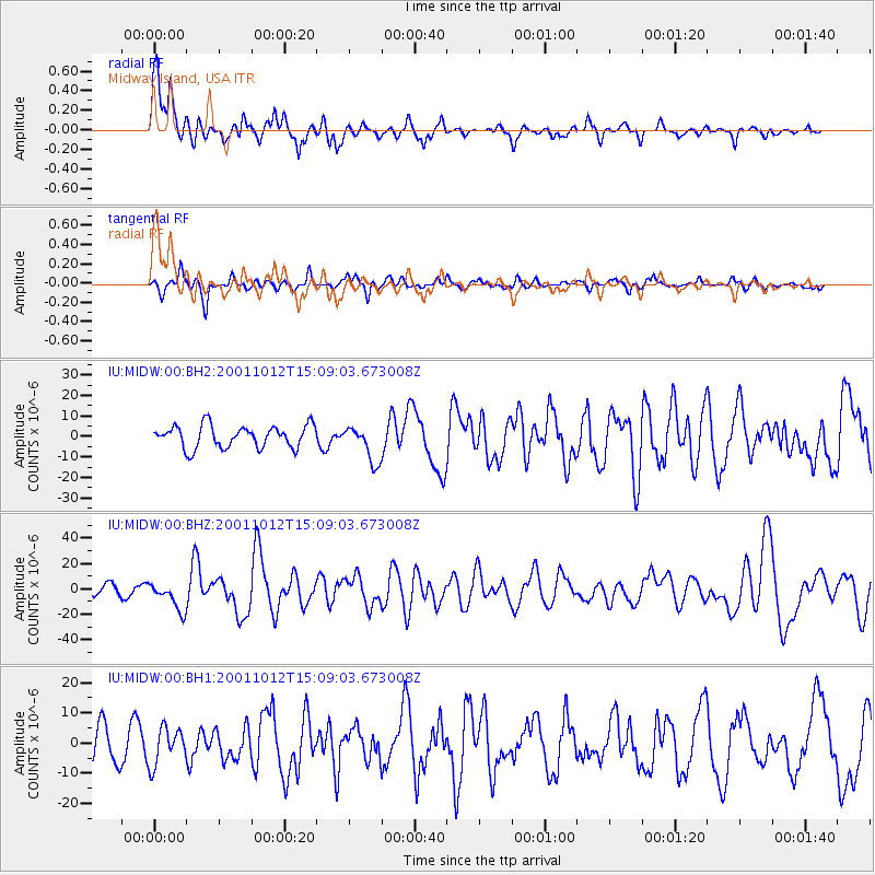
Signal To Noise
| Channel | StoN | STA | LTA |
| IU:MIDW:00:BHZ:20011012T15:09:03.673008Z | 3.1480784 | 1.1289487E-5 | 3.5861517E-6 |
| IU:MIDW:00:BH1:20011012T15:09:03.673008Z | 1.1717803 | 6.0580765E-6 | 5.1699762E-6 |
| IU:MIDW:00:BH2:20011012T15:09:03.673008Z | 1.6325392 | 8.835938E-6 | 5.41239E-6 |
| Arrivals |
| Ps | 2.6 SECOND |
| PpPs | 8.6 SECOND |
| PsPs/PpSs | 11 SECOND |


