You are here: Home > Network List > IU - Global Seismograph Network (GSN - IRIS/USGS) Stations List
> Station POHA Pohakuloa, Hawaii, USA > Earthquake Result Viewer
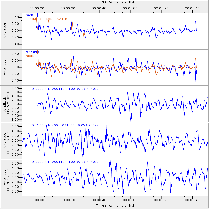
POHA Pohakuloa, Hawaii, USA - Earthquake Result Viewer
*The percent match for this event was below the threshold and hence no stack was calculated.
| Earthquake location: |
Off E. Coast Of N. Island, N.Z. |
| Earthquake latitude/longitude: |
-37.1/179.0 |
| Earthquake time(UTC): |
2001/10/21 (294) 00:29:21 GMT |
| Earthquake Depth: |
18 km |
| Earthquake Magnitude: |
6.0 MB, 6.8 MS, 6.7 MW, 6.6 MW |
| Earthquake Catalog/Contributor: |
WHDF/NEIC |
|
| Network: |
IU Global Seismograph Network (GSN - IRIS/USGS) |
| Station: |
POHA Pohakuloa, Hawaii, USA |
| Lat/Lon: |
19.76 N/155.53 W |
| Elevation: |
1967 m |
|
| Distance: |
61.5 deg |
| Az: |
27.466 deg |
| Baz: |
203.038 deg |
| Ray Param: |
$rayparam |
*The percent match for this event was below the threshold and hence was not used in the summary stack. |
|
| Radial Match: |
73.86336 % |
| Radial Bump: |
361 |
| Transverse Match: |
60.984806 % |
| Transverse Bump: |
400 |
| SOD ConfigId: |
590571 |
| Insert Time: |
2013-09-24 21:40:50.798 +0000 |
| GWidth: |
2.5 |
| Max Bumps: |
400 |
| Tol: |
0.001 |
|
Signal To Noise
| Channel | StoN | STA | LTA |
| IU:POHA:00:BHZ:20011021T00:39:05.89802Z | 1.957089 | 2.6253242E-6 | 1.3414434E-6 |
| IU:POHA:00:BH1:20011021T00:39:05.89802Z | 0.78152394 | 9.62333E-7 | 1.2313545E-6 |
| IU:POHA:00:BH2:20011021T00:39:05.89802Z | 0.78378695 | 1.4942281E-6 | 1.9064211E-6 |
| Arrivals |
| Ps | |
| PpPs | |
| PsPs/PpSs | |


