You are here: Home > Network List > IU - Global Seismograph Network (GSN - IRIS/USGS) Stations List
> Station RSSD Black Hills, South Dakota, USA > Earthquake Result Viewer
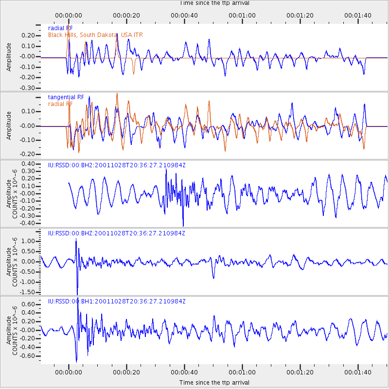
RSSD Black Hills, South Dakota, USA - Earthquake Result Viewer
*The percent match for this event was below the threshold and hence no stack was calculated.
| Earthquake location: |
Fiji Islands Region |
| Earthquake latitude/longitude: |
-21.8/-176.7 |
| Earthquake time(UTC): |
2001/10/28 (301) 20:24:05 GMT |
| Earthquake Depth: |
190 km |
| Earthquake Magnitude: |
5.5 MB, 5.8 MW, 5.6 MW |
| Earthquake Catalog/Contributor: |
WHDF/NEIC |
|
| Network: |
IU Global Seismograph Network (GSN - IRIS/USGS) |
| Station: |
RSSD Black Hills, South Dakota, USA |
| Lat/Lon: |
44.12 N/104.04 W |
| Elevation: |
2060 m |
|
| Distance: |
93.3 deg |
| Az: |
43.525 deg |
| Baz: |
242.705 deg |
| Ray Param: |
$rayparam |
*The percent match for this event was below the threshold and hence was not used in the summary stack. |
|
| Radial Match: |
50.926926 % |
| Radial Bump: |
400 |
| Transverse Match: |
57.239746 % |
| Transverse Bump: |
400 |
| SOD ConfigId: |
590571 |
| Insert Time: |
2013-09-24 21:43:51.886 +0000 |
| GWidth: |
2.5 |
| Max Bumps: |
400 |
| Tol: |
0.001 |
|
Signal To Noise
| Channel | StoN | STA | LTA |
| IU:RSSD:00:BHZ:20011028T20:36:27.210984Z | 2.7948864 | 4.674058E-7 | 1.6723607E-7 |
| IU:RSSD:00:BH1:20011028T20:36:27.210984Z | 4.184289 | 2.6306492E-7 | 6.286969E-8 |
| IU:RSSD:00:BH2:20011028T20:36:27.210984Z | 1.0734025 | 1.3090323E-7 | 1.2195169E-7 |
| Arrivals |
| Ps | |
| PpPs | |
| PsPs/PpSs | |


