You are here: Home > Network List > IU - Global Seismograph Network (GSN - IRIS/USGS) Stations List
> Station JOHN Johnston Island, USA > Earthquake Result Viewer
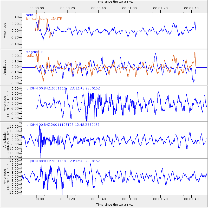
JOHN Johnston Island, USA - Earthquake Result Viewer
*The percent match for this event was below the threshold and hence no stack was calculated.
| Earthquake location: |
Fiji Islands Region |
| Earthquake latitude/longitude: |
-17.3/-179.3 |
| Earthquake time(UTC): |
2001/11/05 (309) 23:07:11 GMT |
| Earthquake Depth: |
564 km |
| Earthquake Magnitude: |
5.4 MB, 6.3 MW, 6.3 MW |
| Earthquake Catalog/Contributor: |
WHDF/NEIC |
|
| Network: |
IU Global Seismograph Network (GSN - IRIS/USGS) |
| Station: |
JOHN Johnston Island, USA |
| Lat/Lon: |
16.73 N/169.53 W |
| Elevation: |
2.0 m |
|
| Distance: |
35.1 deg |
| Az: |
16.328 deg |
| Baz: |
196.279 deg |
| Ray Param: |
$rayparam |
*The percent match for this event was below the threshold and hence was not used in the summary stack. |
|
| Radial Match: |
50.027576 % |
| Radial Bump: |
400 |
| Transverse Match: |
34.95436 % |
| Transverse Bump: |
400 |
| SOD ConfigId: |
590571 |
| Insert Time: |
2013-09-24 21:45:26.044 +0000 |
| GWidth: |
2.5 |
| Max Bumps: |
400 |
| Tol: |
0.001 |
|
Signal To Noise
| Channel | StoN | STA | LTA |
| IU:JOHN:00:BHZ:20011105T23:12:48.235015Z | 1.9954262 | 7.0616147E-6 | 3.5389007E-6 |
| IU:JOHN:00:BH1:20011105T23:12:48.235015Z | 1.1229292 | 3.772017E-6 | 3.3590868E-6 |
| IU:JOHN:00:BH2:20011105T23:12:48.235015Z | 1.3800242 | 4.9135206E-6 | 3.5604596E-6 |
| Arrivals |
| Ps | |
| PpPs | |
| PsPs/PpSs | |


