You are here: Home > Network List > IU - Global Seismograph Network (GSN - IRIS/USGS) Stations List
> Station JOHN Johnston Island, USA > Earthquake Result Viewer
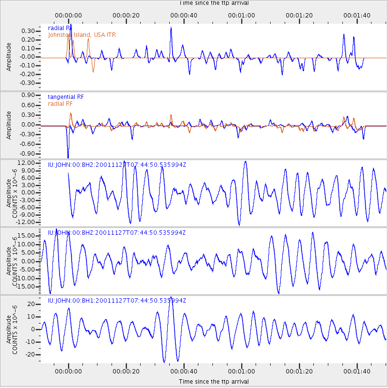
JOHN Johnston Island, USA - Earthquake Result Viewer
*The percent match for this event was below the threshold and hence no stack was calculated.
| Earthquake location: |
Nepal |
| Earthquake latitude/longitude: |
29.6/81.8 |
| Earthquake time(UTC): |
2001/11/27 (331) 07:31:52 GMT |
| Earthquake Depth: |
33 km |
| Earthquake Magnitude: |
5.6 MB, 5.5 MW |
| Earthquake Catalog/Contributor: |
NEIC PDE/NEIC PDE-M |
|
| Network: |
IU Global Seismograph Network (GSN - IRIS/USGS) |
| Station: |
JOHN Johnston Island, USA |
| Lat/Lon: |
16.73 N/169.53 W |
| Elevation: |
2.0 m |
|
| Distance: |
97.3 deg |
| Az: |
66.196 deg |
| Baz: |
303.742 deg |
| Ray Param: |
$rayparam |
*The percent match for this event was below the threshold and hence was not used in the summary stack. |
|
| Radial Match: |
51.92951 % |
| Radial Bump: |
331 |
| Transverse Match: |
46.176178 % |
| Transverse Bump: |
400 |
| SOD ConfigId: |
590571 |
| Insert Time: |
2013-09-24 21:52:05.605 +0000 |
| GWidth: |
2.5 |
| Max Bumps: |
400 |
| Tol: |
0.001 |
|
Signal To Noise
| Channel | StoN | STA | LTA |
| IU:JOHN:00:BHZ:20011127T07:44:50.535994Z | 1.8160484 | 1.0192043E-5 | 5.612209E-6 |
| IU:JOHN:00:BH1:20011127T07:44:50.535994Z | 1.921647 | 1.0343641E-5 | 5.382696E-6 |
| IU:JOHN:00:BH2:20011127T07:44:50.535994Z | 1.1064264 | 6.1922506E-6 | 5.5966225E-6 |
| Arrivals |
| Ps | |
| PpPs | |
| PsPs/PpSs | |


