You are here: Home > Network List > II - Global Seismograph Network (GSN - IRIS/IDA) Stations List
> Station COCO West Island, Cocos (Keeling) Islands > Earthquake Result Viewer
COCO West Island, Cocos (Keeling) Islands - Earthquake Result Viewer
| Earthquake location: |
South Of Australia |
| Earthquake latitude/longitude: |
-42.8/124.7 |
| Earthquake time(UTC): |
2001/12/12 (346) 14:02:35 GMT |
| Earthquake Depth: |
10 km |
| Earthquake Magnitude: |
6.5 MB, 6.7 MS, 7.1 MW, 7.0 MW |
| Earthquake Catalog/Contributor: |
WHDF/NEIC |
|
| Network: |
II Global Seismograph Network (GSN - IRIS/IDA) |
| Station: |
COCO West Island, Cocos (Keeling) Islands |
| Lat/Lon: |
12.19 S/96.83 E |
| Elevation: |
1.0 m |
|
| Distance: |
38.9 deg |
| Az: |
313.334 deg |
| Baz: |
146.81 deg |
| Ray Param: |
0.07529202 |
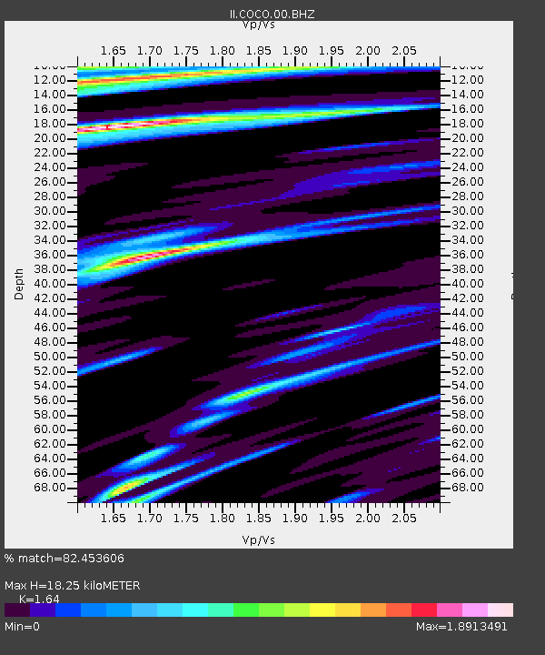
| Estimated Moho Depth: |
18.25 km |
| Estimated Crust Vp/Vs: |
1.64 |
| Assumed Crust Vp: |
4.24 km/s |
| Estimated Crust Vs: |
2.585 km/s |
| Estimated Crust Poisson's Ratio: |
0.20 |
|
| Radial Match: |
82.453606 % |
| Radial Bump: |
363 |
| Transverse Match: |
75.662445 % |
| Transverse Bump: |
400 |
| SOD ConfigId: |
590571 |
| Insert Time: |
2013-09-24 21:58:47.273 +0000 |
| GWidth: |
2.5 |
| Max Bumps: |
400 |
| Tol: |
0.001 |
|
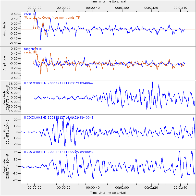
Signal To Noise
| Channel | StoN | STA | LTA |
| II:COCO:00:BHZ:20011212T14:09:29.894004Z | 4.7063627 | 1.5805585E-6 | 3.3583441E-7 |
| II:COCO:00:BH1:20011212T14:09:29.894004Z | 1.0596584 | 7.775452E-7 | 7.337697E-7 |
| II:COCO:00:BH2:20011212T14:09:29.894004Z | 1.1049838 | 8.9299454E-7 | 8.081517E-7 |
| Arrivals |
| Ps | 2.8 SECOND |
| PpPs | 11 SECOND |
| PsPs/PpSs | 14 SECOND |


