You are here: Home > Network List > IU - Global Seismograph Network (GSN - IRIS/USGS) Stations List
> Station RSSD Black Hills, South Dakota, USA > Earthquake Result Viewer
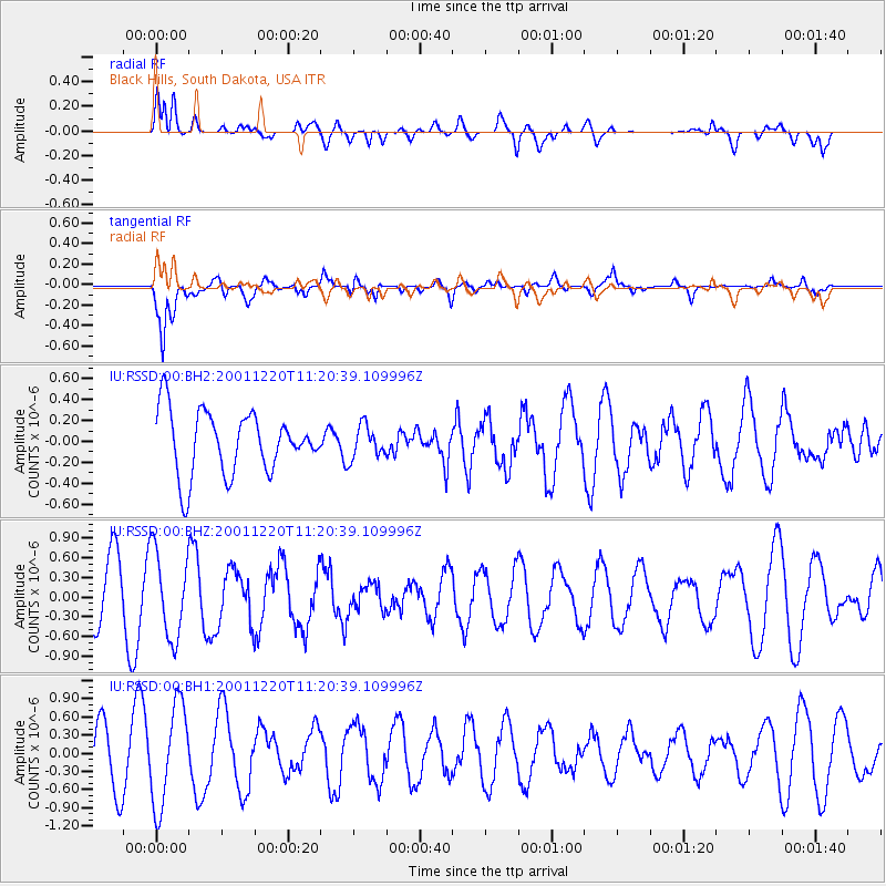
RSSD Black Hills, South Dakota, USA - Earthquake Result Viewer
*The percent match for this event was below the threshold and hence no stack was calculated.
| Earthquake location: |
Alaska Peninsula |
| Earthquake latitude/longitude: |
54.2/-162.5 |
| Earthquake time(UTC): |
2001/12/20 (354) 11:13:50 GMT |
| Earthquake Depth: |
33 km |
| Earthquake Magnitude: |
5.5 MW, 5.6 MW, 5.6 MB |
| Earthquake Catalog/Contributor: |
NEIC PDE/NEIC PDE-M |
|
| Network: |
IU Global Seismograph Network (GSN - IRIS/USGS) |
| Station: |
RSSD Black Hills, South Dakota, USA |
| Lat/Lon: |
44.12 N/104.04 W |
| Elevation: |
2060 m |
|
| Distance: |
38.5 deg |
| Az: |
80.429 deg |
| Baz: |
306.396 deg |
| Ray Param: |
$rayparam |
*The percent match for this event was below the threshold and hence was not used in the summary stack. |
|
| Radial Match: |
59.85152 % |
| Radial Bump: |
400 |
| Transverse Match: |
83.17849 % |
| Transverse Bump: |
400 |
| SOD ConfigId: |
590571 |
| Insert Time: |
2013-09-24 21:59:59.687 +0000 |
| GWidth: |
2.5 |
| Max Bumps: |
400 |
| Tol: |
0.001 |
|
Signal To Noise
| Channel | StoN | STA | LTA |
| IU:RSSD:00:BHZ:20011220T11:20:39.109996Z | 1.8049024 | 6.554692E-7 | 3.6316047E-7 |
| IU:RSSD:00:BH1:20011220T11:20:39.109996Z | 2.4362397 | 8.2979057E-7 | 3.4060298E-7 |
| IU:RSSD:00:BH2:20011220T11:20:39.109996Z | 0.5210577 | 1.5581936E-7 | 2.9904433E-7 |
| Arrivals |
| Ps | |
| PpPs | |
| PsPs/PpSs | |


