You are here: Home > Network List > II - Global Seismograph Network (GSN - IRIS/IDA) Stations List
> Station PALK Pallekele, Sri Lanka > Earthquake Result Viewer
PALK Pallekele, Sri Lanka - Earthquake Result Viewer
| Earthquake location: |
Mindanao, Philippines |
| Earthquake latitude/longitude: |
6.3/125.7 |
| Earthquake time(UTC): |
2002/01/01 (001) 11:29:22 GMT |
| Earthquake Depth: |
138 km |
| Earthquake Magnitude: |
5.9 MB, 6.3 MW, 6.3 MW |
| Earthquake Catalog/Contributor: |
WHDF/NEIC |
|
| Network: |
II Global Seismograph Network (GSN - IRIS/IDA) |
| Station: |
PALK Pallekele, Sri Lanka |
| Lat/Lon: |
7.27 N/80.70 E |
| Elevation: |
460 m |
|
| Distance: |
44.6 deg |
| Az: |
273.953 deg |
| Baz: |
88.392 deg |
| Ray Param: |
0.071293436 |
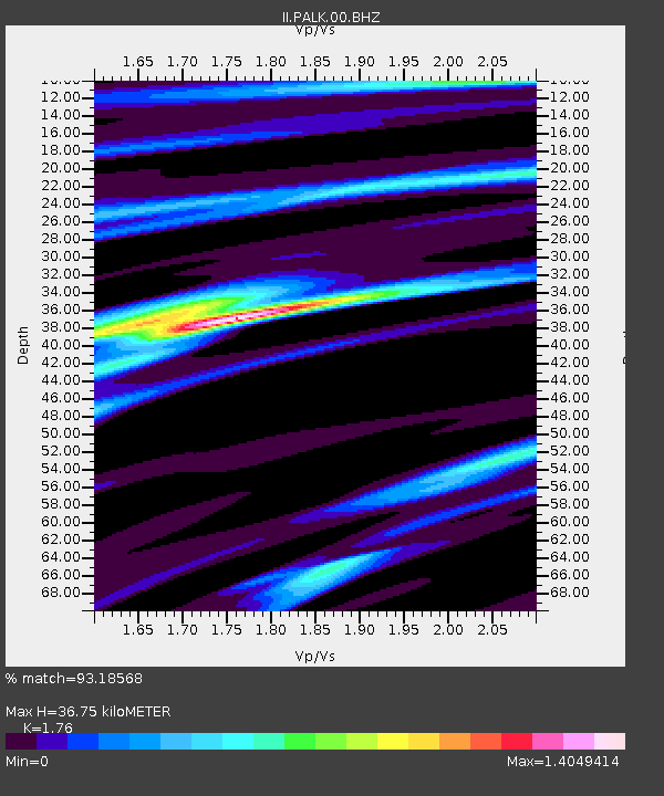
| Estimated Moho Depth: |
36.75 km |
| Estimated Crust Vp/Vs: |
1.76 |
| Assumed Crust Vp: |
6.545 km/s |
| Estimated Crust Vs: |
3.719 km/s |
| Estimated Crust Poisson's Ratio: |
0.26 |
|
| Radial Match: |
93.18568 % |
| Radial Bump: |
304 |
| Transverse Match: |
81.61002 % |
| Transverse Bump: |
400 |
| SOD ConfigId: |
590571 |
| Insert Time: |
2013-09-24 22:03:50.726 +0000 |
| GWidth: |
2.5 |
| Max Bumps: |
400 |
| Tol: |
0.001 |
|
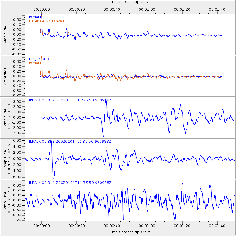
Signal To Noise
| Channel | StoN | STA | LTA |
| II:PALK:00:BHZ:20020101T11:36:50.960988Z | 4.3220735 | 1.094754E-6 | 2.5329368E-7 |
| II:PALK:00:BH1:20020101T11:36:50.960988Z | 0.64407283 | 1.07153454E-7 | 1.6636854E-7 |
| II:PALK:00:BH2:20020101T11:36:50.960988Z | 2.6123302 | 6.7582647E-7 | 2.5870636E-7 |
| Arrivals |
| Ps | 4.6 SECOND |
| PpPs | 14 SECOND |
| PsPs/PpSs | 19 SECOND |


