You are here: Home > Network List > IU - Global Seismograph Network (GSN - IRIS/USGS) Stations List
> Station JOHN Johnston Island, USA > Earthquake Result Viewer
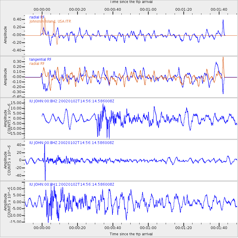
JOHN Johnston Island, USA - Earthquake Result Viewer
*The percent match for this event was below the threshold and hence no stack was calculated.
| Earthquake location: |
Fiji Islands |
| Earthquake latitude/longitude: |
-18.0/178.7 |
| Earthquake time(UTC): |
2002/01/02 (002) 14:50:33 GMT |
| Earthquake Depth: |
666 km |
| Earthquake Magnitude: |
6.2 MW |
| Earthquake Catalog/Contributor: |
NEIC PDE/NEIC PDE-M |
|
| Network: |
IU Global Seismograph Network (GSN - IRIS/USGS) |
| Station: |
JOHN Johnston Island, USA |
| Lat/Lon: |
16.73 N/169.53 W |
| Elevation: |
2.0 m |
|
| Distance: |
36.4 deg |
| Az: |
19.168 deg |
| Baz: |
199.035 deg |
| Ray Param: |
$rayparam |
*The percent match for this event was below the threshold and hence was not used in the summary stack. |
|
| Radial Match: |
46.267666 % |
| Radial Bump: |
400 |
| Transverse Match: |
46.483074 % |
| Transverse Bump: |
400 |
| SOD ConfigId: |
590571 |
| Insert Time: |
2013-09-24 22:04:35.413 +0000 |
| GWidth: |
2.5 |
| Max Bumps: |
400 |
| Tol: |
0.001 |
|
Signal To Noise
| Channel | StoN | STA | LTA |
| IU:JOHN:00:BHZ:20020102T14:56:14.586008Z | 3.3207374 | 1.277192E-5 | 3.84611E-6 |
| IU:JOHN:00:BH1:20020102T14:56:14.586008Z | 1.505934 | 5.426014E-6 | 3.6030888E-6 |
| IU:JOHN:00:BH2:20020102T14:56:14.586008Z | 1.7561332 | 6.808311E-6 | 3.8768762E-6 |
| Arrivals |
| Ps | |
| PpPs | |
| PsPs/PpSs | |


