You are here: Home > Network List > IU - Global Seismograph Network (GSN - IRIS/USGS) Stations List
> Station JOHN Johnston Island, USA > Earthquake Result Viewer
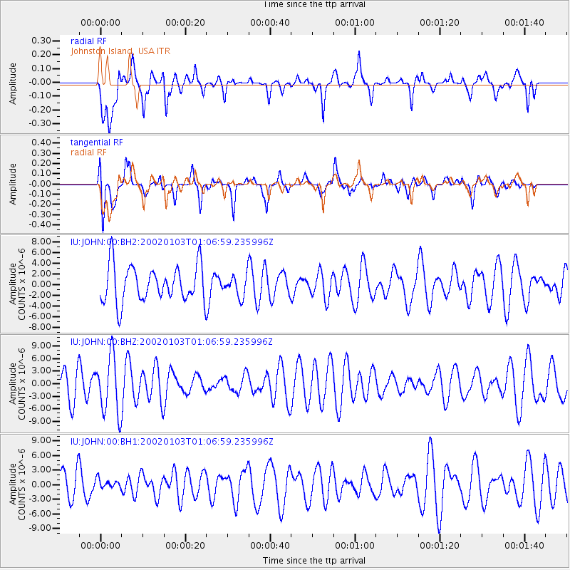
JOHN Johnston Island, USA - Earthquake Result Viewer
*The percent match for this event was below the threshold and hence no stack was calculated.
| Earthquake location: |
Southern Sumatra, Indonesia |
| Earthquake latitude/longitude: |
-4.3/102.0 |
| Earthquake time(UTC): |
2002/01/03 (003) 00:54:35 GMT |
| Earthquake Depth: |
33 km |
| Earthquake Magnitude: |
5.6 MW |
| Earthquake Catalog/Contributor: |
NEIC PDE/NEIC PDE-M |
|
| Network: |
IU Global Seismograph Network (GSN - IRIS/USGS) |
| Station: |
JOHN Johnston Island, USA |
| Lat/Lon: |
16.73 N/169.53 W |
| Elevation: |
2.0 m |
|
| Distance: |
89.7 deg |
| Az: |
73.303 deg |
| Baz: |
265.427 deg |
| Ray Param: |
$rayparam |
*The percent match for this event was below the threshold and hence was not used in the summary stack. |
|
| Radial Match: |
43.34629 % |
| Radial Bump: |
400 |
| Transverse Match: |
48.258663 % |
| Transverse Bump: |
400 |
| SOD ConfigId: |
590571 |
| Insert Time: |
2013-09-24 22:05:19.905 +0000 |
| GWidth: |
2.5 |
| Max Bumps: |
400 |
| Tol: |
0.001 |
|
Signal To Noise
| Channel | StoN | STA | LTA |
| IU:JOHN:00:BHZ:20020103T01:06:59.235996Z | 2.443533 | 7.052086E-6 | 2.8860204E-6 |
| IU:JOHN:00:BH1:20020103T01:06:59.235996Z | 0.28542897 | 9.235885E-7 | 3.235791E-6 |
| IU:JOHN:00:BH2:20020103T01:06:59.235996Z | 0.60304767 | 2.0646469E-6 | 3.4236875E-6 |
| Arrivals |
| Ps | |
| PpPs | |
| PsPs/PpSs | |


