You are here: Home > Network List > IU - Global Seismograph Network (GSN - IRIS/USGS) Stations List
> Station RSSD Black Hills, South Dakota, USA > Earthquake Result Viewer
RSSD Black Hills, South Dakota, USA - Earthquake Result Viewer
*The percent match for this event was below the threshold and hence no stack was calculated.
| Earthquake location: |
Mariana Islands |
| Earthquake latitude/longitude: |
19.0/145.0 |
| Earthquake time(UTC): |
2002/01/07 (007) 13:26:26 GMT |
| Earthquake Depth: |
599 km |
| Earthquake Magnitude: |
5.7 MB, 5.9 MW, 5.9 MW |
| Earthquake Catalog/Contributor: |
WHDF/NEIC |
|
| Network: |
IU Global Seismograph Network (GSN - IRIS/USGS) |
| Station: |
RSSD Black Hills, South Dakota, USA |
| Lat/Lon: |
44.12 N/104.04 W |
| Elevation: |
2060 m |
|
| Distance: |
91.2 deg |
| Az: |
42.259 deg |
| Baz: |
297.906 deg |
| Ray Param: |
$rayparam |
*The percent match for this event was below the threshold and hence was not used in the summary stack. |
|
| Radial Match: |
75.41167 % |
| Radial Bump: |
400 |
| Transverse Match: |
62.9955 % |
| Transverse Bump: |
400 |
| SOD ConfigId: |
590571 |
| Insert Time: |
2013-09-24 22:08:15.189 +0000 |
| GWidth: |
2.5 |
| Max Bumps: |
400 |
| Tol: |
0.001 |
|
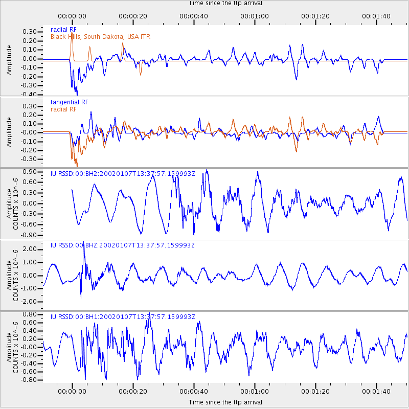
Signal To Noise
| Channel | StoN | STA | LTA |
| IU:RSSD:00:BHZ:20020107T13:37:57.159993Z | 1.850304 | 8.008222E-7 | 4.3280573E-7 |
| IU:RSSD:00:BH1:20020107T13:37:57.159993Z | 1.3542033 | 3.7167104E-7 | 2.744573E-7 |
| IU:RSSD:00:BH2:20020107T13:37:57.159993Z | 1.6432598 | 5.906068E-7 | 3.594117E-7 |
| Arrivals |
| Ps | |
| PpPs | |
| PsPs/PpSs | |


