You are here: Home > Network List > IU - Global Seismograph Network (GSN - IRIS/USGS) Stations List
> Station POHA Pohakuloa, Hawaii, USA > Earthquake Result Viewer
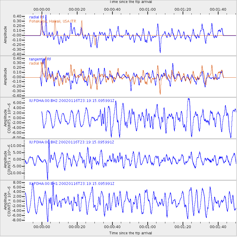
POHA Pohakuloa, Hawaii, USA - Earthquake Result Viewer
*The percent match for this event was below the threshold and hence no stack was calculated.
| Earthquake location: |
Near Coast Of Chiapas, Mexico |
| Earthquake latitude/longitude: |
15.5/-93.1 |
| Earthquake time(UTC): |
2002/01/16 (016) 23:09:52 GMT |
| Earthquake Depth: |
80 km |
| Earthquake Magnitude: |
5.8 MB, 6.4 MW, 6.4 MW |
| Earthquake Catalog/Contributor: |
WHDF/NEIC |
|
| Network: |
IU Global Seismograph Network (GSN - IRIS/USGS) |
| Station: |
POHA Pohakuloa, Hawaii, USA |
| Lat/Lon: |
19.76 N/155.53 W |
| Elevation: |
1967 m |
|
| Distance: |
59.3 deg |
| Az: |
283.997 deg |
| Baz: |
83.319 deg |
| Ray Param: |
$rayparam |
*The percent match for this event was below the threshold and hence was not used in the summary stack. |
|
| Radial Match: |
58.98746 % |
| Radial Bump: |
400 |
| Transverse Match: |
64.560104 % |
| Transverse Bump: |
400 |
| SOD ConfigId: |
590571 |
| Insert Time: |
2013-09-24 22:12:27.425 +0000 |
| GWidth: |
2.5 |
| Max Bumps: |
400 |
| Tol: |
0.001 |
|
Signal To Noise
| Channel | StoN | STA | LTA |
| IU:POHA:00:BHZ:20020116T23:19:15.095991Z | 2.6263096 | 5.6441277E-6 | 2.1490719E-6 |
| IU:POHA:00:BH1:20020116T23:19:15.095991Z | 1.2129183 | 3.2840283E-6 | 2.7075428E-6 |
| IU:POHA:00:BH2:20020116T23:19:15.095991Z | 0.62683886 | 1.3923149E-6 | 2.2211686E-6 |
| Arrivals |
| Ps | |
| PpPs | |
| PsPs/PpSs | |


