You are here: Home > Network List > IU - Global Seismograph Network (GSN - IRIS/USGS) Stations List
> Station RSSD Black Hills, South Dakota, USA > Earthquake Result Viewer
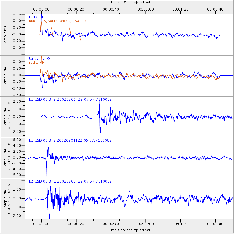
RSSD Black Hills, South Dakota, USA - Earthquake Result Viewer
*The percent match for this event was below the threshold and hence no stack was calculated.
| Earthquake location: |
Primor'ye, Russia |
| Earthquake latitude/longitude: |
45.5/136.7 |
| Earthquake time(UTC): |
2002/02/01 (032) 21:55:20 GMT |
| Earthquake Depth: |
356 km |
| Earthquake Magnitude: |
6.2 MB, 6.0 MW, 5.9 MW |
| Earthquake Catalog/Contributor: |
WHDF/NEIC |
|
| Network: |
IU Global Seismograph Network (GSN - IRIS/USGS) |
| Station: |
RSSD Black Hills, South Dakota, USA |
| Lat/Lon: |
44.12 N/104.04 W |
| Elevation: |
2060 m |
|
| Distance: |
75.8 deg |
| Az: |
40.407 deg |
| Baz: |
320.699 deg |
| Ray Param: |
$rayparam |
*The percent match for this event was below the threshold and hence was not used in the summary stack. |
|
| Radial Match: |
65.62184 % |
| Radial Bump: |
400 |
| Transverse Match: |
71.98225 % |
| Transverse Bump: |
400 |
| SOD ConfigId: |
590571 |
| Insert Time: |
2013-09-24 22:17:55.839 +0000 |
| GWidth: |
2.5 |
| Max Bumps: |
400 |
| Tol: |
0.001 |
|
Signal To Noise
| Channel | StoN | STA | LTA |
| IU:RSSD:00:BHZ:20020201T22:05:57.711008Z | 7.641977 | 1.8345834E-6 | 2.400666E-7 |
| IU:RSSD:00:BH1:20020201T22:05:57.711008Z | 6.6504593 | 6.980625E-7 | 1.0496454E-7 |
| IU:RSSD:00:BH2:20020201T22:05:57.711008Z | 8.066849 | 8.327724E-7 | 1.0323391E-7 |
| Arrivals |
| Ps | |
| PpPs | |
| PsPs/PpSs | |


